IMAGES TAKEN NEAR TO
Maple Close, ROMSEY, SO51 5RZ
Introduction
This page details the photographs taken nearby to Maple Close, SO51 5RZ by members of the Geograph project.
The Geograph project started in 2005 with the aim of publishing, organising and preserving representative images for every square kilometre of Great Britain, Ireland and the Isle of Man.

There are currently over 7.5m images from over14,400 individuals and you can help contribute to the project by visiting https://www.geograph.org.uk
Image Map
Images are licensed for reuse under creativecommons.org/licenses/by-sa/2.0
Notes
- Clicking on the map will re-center to the selected point.
- The higher the marker number, the further away the image location is from the centre of the postcode.
Image Listing (9 Images Found)
Images are licensed for reuse under creativecommons.org/licenses/by-sa/2.0
Image
Details
Distance
1
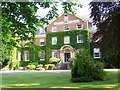
Montfort College, Romsey
This rather fine building has been converted into residential apartments. It was previously a Catholic seminary run by the Montfort Fathers.
Image: © David Martin
Taken: 23 May 2008
0.13 miles
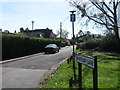
5
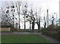
Road junction with mistletoe on the Botley Road
The junction of the Botley Road and Whitenap Lane. There is mistletoe here every year on these trees on the corner of the Whitenap recreation area, but not usually in such profusion.
Image: © Rosemary Oakeshott
Taken: 9 Dec 2007
0.23 miles