IMAGES TAKEN NEAR TO
Anton Close, ROMSEY, SO51 5QD
Introduction
This page details the photographs taken nearby to Anton Close, SO51 5QD by members of the Geograph project.
The Geograph project started in 2005 with the aim of publishing, organising and preserving representative images for every square kilometre of Great Britain, Ireland and the Isle of Man.

There are currently over 7.5m images from over14,400 individuals and you can help contribute to the project by visiting https://www.geograph.org.uk
Image Map (Loading...)


Getting Data...Please wait
Leaflet Map data © OpenStreetMap
Images are licensed for reuse under creativecommons.org/licenses/by-sa/2.0
Notes
- Clicking on the map will re-center to the selected point.
- The higher the marker number, the further away the image location is from the centre of the postcode.
Image Listing (8 Images Found)
Images are licensed for reuse under creativecommons.org/licenses/by-sa/2.0
Image
Details
Distance
3
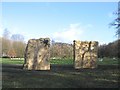
Tadburn Meadows Sculpture Trail
From the distance this gate appears to be a serious piece of modern sculpture. It combines the functions of climbing wall and net - for those who don't mind spiders.
Image: © Rosemary Oakeshott
Taken: 1 Feb 2008
0.17 miles
4
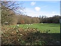
Tadburn Meadows Sculpture Trail
This Play Sculpture Trail is in the corner of Tadburn Meadows Nature Reserve. It is basically a children's play area but with limestone sculptures designed to be educational as well as recreational.
Image: © Rosemary Oakeshott
Taken: 6 Feb 2008
0.18 miles
8

Montfort College, Romsey
This rather fine building has been converted into residential apartments. It was previously a Catholic seminary run by the Montfort Fathers.
Image: © David Martin
Taken: 23 May 2008
0.22 miles