IMAGES TAKEN NEAR TO
Oakleigh Gardens, ROMSEY, SO51 5AS
Introduction
This page details the photographs taken nearby to Oakleigh Gardens, SO51 5AS by members of the Geograph project.
The Geograph project started in 2005 with the aim of publishing, organising and preserving representative images for every square kilometre of Great Britain, Ireland and the Isle of Man.

There are currently over 7.5m images from over14,400 individuals and you can help contribute to the project by visiting https://www.geograph.org.uk
Image Map
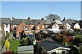
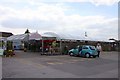
Images are licensed for reuse under creativecommons.org/licenses/by-sa/2.0
Notes
- Clicking on the map will re-center to the selected point.
- The higher the marker number, the further away the image location is from the centre of the postcode.
Image Listing (90 Images Found)
Images are licensed for reuse under creativecommons.org/licenses/by-sa/2.0
Image
Details
Distance
2
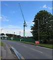
Crane towers over a Botley Road construction site in Romsey
Viewed at the end of May 2015. The site was formerly a garden centre.
Image: © Jaggery
Taken: 31 May 2015
0.06 miles
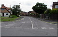
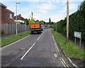
3
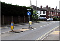
Botley Road pedestrian refuge, Romsey
I feel safer crossing a busy road when a refuge such as this one is available so that crossing the road can be done in two goes, without waiting for a clearance in both directions. However, the presence of the white arrows suggests that this may be an area where some vehicles are approaching on the wrong side of the road...
Image: © Jaggery
Taken: 31 May 2015
0.08 miles
4
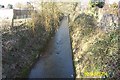
Tadburn Lake, Romsey
Despite its name Tadburn Lake is a river which flows through Romsey to the River Test. This view was taken looking westwards and downstream along a man-made conduit from the Symes Road bridge towards the Hillside Avenue bridge.
Image: © Nigel Cox
Taken: 2 Mar 2004
0.08 miles
5
Tadburn Road, Romsey
South from Botley Road.
Image: © Jaggery
Taken: 31 May 2015
0.10 miles
6
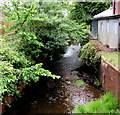
Romsey lake is a stream
Viewed from Botley Road, Romsey. Both here and on maps, it looks like a stream (or small river),
flows like a stream, but is named Tadburn Lake, a tributary of the River Test.
Image: © Jaggery
Taken: 31 May 2015
0.11 miles
7
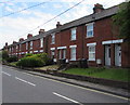
Botley Road houses, Romsey
From the corner of Tadfield Road. http://www.geograph.org.uk/photo/4504623
Image: © Jaggery
Taken: 31 May 2015
0.11 miles
8
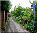
Footpath towards Romsey town centre
From Botley Road along the south bank of a stream confusingly named Tadburn Lake.
Image: © Jaggery
Taken: 31 May 2015
0.11 miles
9
Tadfield Road, Romsey
Viewed from Botley Road. Tadfield Road leads to Tadfield Crescent.
Image: © Jaggery
Taken: 31 May 2015
0.12 miles