IMAGES TAKEN NEAR TO
Casbrook Common, ROMSEY, SO51 0PU
Introduction
This page details the photographs taken nearby to Casbrook Common, SO51 0PU by members of the Geograph project.
The Geograph project started in 2005 with the aim of publishing, organising and preserving representative images for every square kilometre of Great Britain, Ireland and the Isle of Man.

There are currently over 7.5m images from over14,400 individuals and you can help contribute to the project by visiting https://www.geograph.org.uk
Image Map
Images are licensed for reuse under creativecommons.org/licenses/by-sa/2.0
Notes
- Clicking on the map will re-center to the selected point.
- The higher the marker number, the further away the image location is from the centre of the postcode.
Image Listing (6 Images Found)
Images are licensed for reuse under creativecommons.org/licenses/by-sa/2.0
Image
Details
Distance
1
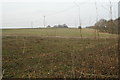
Cranford Farm
View north from the crossroads
Image: © Pierre Terre
Taken: 23 Mar 2006
0.15 miles
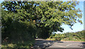
3
Bunny Lane
The north end of Bunny Lane, with catkins
Image: © Pierre Terre
Taken: 23 Mar 2006
0.18 miles
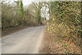
4
Finger post
An old fashioned finger post at the junction of Bunny Lane and Rudd Lane
Image: © Pierre Terre
Taken: 23 Mar 2006
0.18 miles
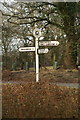
5
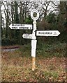
Old Direction Sign - Signpost west of Braishfield
Annulus finial - 3 arms; Hants halo by the UC Road, in parish of Braishfield (Test Valley District), junction of Bunny Lane and Rudd Lane.
To be surveyed
Milestone Society National ID: HA_SU3625A.
Image: © Milestone Society
Taken: Unknown
0.18 miles
6
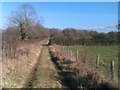
Footpath on farm track near Michelmersh
Image: © David Martin
Taken: 26 Feb 2012
0.23 miles