IMAGES TAKEN NEAR TO
Paynes Hay Road, ROMSEY, SO51 0PS
Introduction
This page details the photographs taken nearby to Paynes Hay Road, SO51 0PS by members of the Geograph project.
The Geograph project started in 2005 with the aim of publishing, organising and preserving representative images for every square kilometre of Great Britain, Ireland and the Isle of Man.

There are currently over 7.5m images from over14,400 individuals and you can help contribute to the project by visiting https://www.geograph.org.uk
Image Map
Images are licensed for reuse under creativecommons.org/licenses/by-sa/2.0
Notes
- Clicking on the map will re-center to the selected point.
- The higher the marker number, the further away the image location is from the centre of the postcode.
Image Listing (10 Images Found)
Images are licensed for reuse under creativecommons.org/licenses/by-sa/2.0
Image
Details
Distance
1
Finger posts on Monarch's way
Looking SE where Monarch's Way crosses Paynes Hay Road to the NW of the square
Image: © Pierre Terre
Taken: 23 Mar 2006
0.05 miles
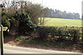
2
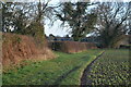
Corner of field beside Paynes Hay Road
Image: © David Martin
Taken: 15 Jan 2023
0.06 miles
3
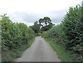
Paynes Hay Road northeast of Paynes Hay Farm
Image: © Stuart Logan
Taken: 11 Sep 2013
0.10 miles
4
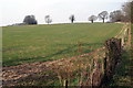
West of Braishfield Manor
Looking NW across the large field in the SW corner of the square
Image: © Pierre Terre
Taken: 23 Mar 2006
0.15 miles
5
Monarch's Way path towards Braishfield
Image: © David Martin
Taken: 15 Jan 2023
0.17 miles
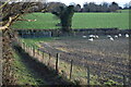
6
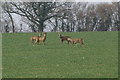
Roe Deer, Braishfield Manor
Apparently a serious pest
Image: © Pierre Terre
Taken: 23 Mar 2006
0.17 miles
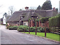
9
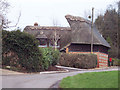
Interesting thatched cottage at Braishfield
Image: © Maigheach-gheal
Taken: 16 Feb 2007
0.22 miles
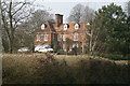
10
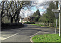
The Gatehouse and Paynes Hay Road
Just west of the crossroads to the north of the centre of Braishfield, is this Grade II listed cottage from the late 18th early 19th C. It is Grade II with English Heritage Building ID: 140864.
Image: © Stuart Logan
Taken: 14 Feb 2013
0.23 miles