IMAGES TAKEN NEAR TO
Braishfield Road, ROMSEY, SO51 0PN
Introduction
This page details the photographs taken nearby to Braishfield Road, SO51 0PN by members of the Geograph project.
The Geograph project started in 2005 with the aim of publishing, organising and preserving representative images for every square kilometre of Great Britain, Ireland and the Isle of Man.

There are currently over 7.5m images from over14,400 individuals and you can help contribute to the project by visiting https://www.geograph.org.uk
Image Map (Loading...)


Getting Data...Please wait
Leaflet Map data © OpenStreetMap
Images are licensed for reuse under creativecommons.org/licenses/by-sa/2.0
Notes
- Clicking on the map will re-center to the selected point.
- The higher the marker number, the further away the image location is from the centre of the postcode.
Image Listing (29 Images Found)
Images are licensed for reuse under creativecommons.org/licenses/by-sa/2.0
Image
Details
Distance
1
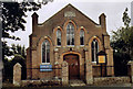
Braishfield United Reformed Church
Erected in 1818 and rebuilt in 1906.
Image: © Michael FORD
Taken: Unknown
0.03 miles
2
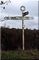
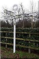
Old Direction Sign - Signpost by Braishfield Road, Braishfield Prish
Annulus finial - 3 arms; Hants halo by the UC Road, in parish of Braishfield (Test Valley District), junction of Braishfield Road with Newport Lane.
To be surveyed
Milestone Society National ID: HA_SU3725A
Image: © Milestone Society
Taken: Unknown
0.07 miles
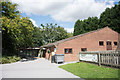
4
Braishfield recreation ground
Viewed from the south west corner next to the school gate
Image: © David Martin
Taken: 30 May 2009
0.09 miles
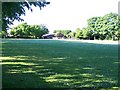
5
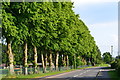
Line of trees beside the recreation ground, Braishfield
Image: © David Martin
Taken: 26 May 2018
0.10 miles
6
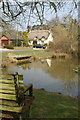
Duck Pond, Braishfield
No ducks around today
Image: © Pierre Terre
Taken: 23 Mar 2006
0.12 miles
7
Old Direction Sign - Signpost by Braishfield Road, Braishfield
Annulus finial - 3 arms; Hants. halo by the UC Road, in parish of Braishfield (Test Valley District), opposite junction of Braishfield Road with Dummers Road.
To be surveyed
Milestone Society National ID: HA_SU3725B
Image: © Milestone Society
Taken: Unknown
0.13 miles

9
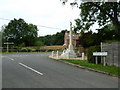
War memorial, Braishfield
AS seen from Dummers Road.
Image: © Basher Eyre
Taken: 28 Jun 2011
0.14 miles
10
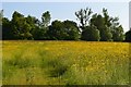
Buttercup field opposite Braishfield cricket ground
Image: © David Martin
Taken: 26 May 2018
0.14 miles