IMAGES TAKEN NEAR TO
Barley Hill/Mill Rise, Barley Hill, ROMSEY, SO51 0LF
Introduction
This page details the photographs taken nearby to Barley Hill/Mill Rise, Barley Hill, SO51 0LF by members of the Geograph project.
The Geograph project started in 2005 with the aim of publishing, organising and preserving representative images for every square kilometre of Great Britain, Ireland and the Isle of Man.

There are currently over 7.5m images from over14,400 individuals and you can help contribute to the project by visiting https://www.geograph.org.uk
Image Map (Loading...)


Getting Data...Please wait
Leaflet Map data © OpenStreetMap
Images are licensed for reuse under creativecommons.org/licenses/by-sa/2.0
Notes
- Clicking on the map will re-center to the selected point.
- The higher the marker number, the further away the image location is from the centre of the postcode.
Image Listing (47 Images Found)
Images are licensed for reuse under creativecommons.org/licenses/by-sa/2.0
Image
Details
Distance
3
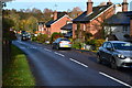
Barley Hill, Dunbridge
The B3084 winds up from the station towards Awbridge and Romsey. There are always parked cars by the road but fortunately there is not much traffic.
Image: © Rosemary Oakeshott
Taken: 21 Nov 2007
0.06 miles
4
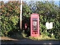
Telephone and Postbox in Dunbridge
The telephone post box and notice board stand beside the road in the centre of the hamlet of Dunbridge.
Image: © Rosemary Oakeshott
Taken: 21 Nov 2007
0.06 miles
5
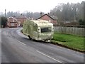
Dumped caravan in Dunbridge
This caravan has just been dumped at the bottom of Barley Hill: how it arrived there and why that public spot was chosen to abandon it is a mystery.
Image: © Rosemary Oakeshott
Taken: 20 Feb 2008
0.08 miles
6
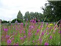
Waste ground near Dunbridge Station
An area of waste ground near to the station with a rich growth of ragwort and fireweed.
Image: © Maigheach-gheal
Taken: 19 Jul 2008
0.13 miles
7
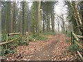
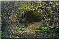
Gateway to public footpath out of Dunbridge
The path gives access to the conifer plantation and is used by local dog walkers and others. The gate had a padlock and chain at one time but this is now attached to the stile and the gate has gone.
Image: © Rosemary Oakeshott
Taken: 20 Feb 2008
0.15 miles
8
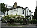
The Mill Arms at Dunbridge
Well worth a stop if in the area.
Image: © Gillian Thomas
Taken: 26 Apr 2007
0.15 miles
9
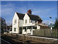
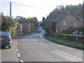
Mottisfont & Dunbridge Station
Since Mottisfont lost its own station when the "Sprat and Winkle" Andover Redbridge line closed in 1964 this is the nearest station to Mottisfont Abbey. The station is unmanned and the station house is now a private home.
Image: © Rosemary Oakeshott
Taken: 21 Nov 2007
0.15 miles
10

A train for Southampton and Romsey departing from Mottisfont and Dunbridge station
Operated by a South Western Railway class 158. The station was previously named Dunbridge but became Mottisfont and Dunbridge in 2006.
Image: © John Lucas
Taken: 13 Oct 2020
0.15 miles