IMAGES TAKEN NEAR TO
Chapel Lane, ROMSEY, SO51 0JW
Introduction
This page details the photographs taken nearby to Chapel Lane, SO51 0JW by members of the Geograph project.
The Geograph project started in 2005 with the aim of publishing, organising and preserving representative images for every square kilometre of Great Britain, Ireland and the Isle of Man.

There are currently over 7.5m images from over14,400 individuals and you can help contribute to the project by visiting https://www.geograph.org.uk
Image Map
Images are licensed for reuse under creativecommons.org/licenses/by-sa/2.0
Notes
- Clicking on the map will re-center to the selected point.
- The higher the marker number, the further away the image location is from the centre of the postcode.
Image Listing (33 Images Found)
Images are licensed for reuse under creativecommons.org/licenses/by-sa/2.0
Image
Details
Distance
7
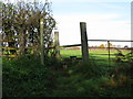
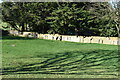
Lockerley Old Baptist Burial Ground
The Chapel was demolished in 1967 but the burial ground still exists.
Image: © Michael FORD
Taken: Unknown
0.05 miles
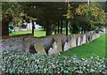
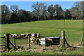
8
Grave stones near Chapel Farm
Send two Geographers to a grid square and this is what happens! See http://www.geograph.org.uk/photo/2155428
Image: © Nick Smith
Taken: 24 Nov 2010
0.05 miles
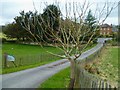
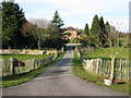
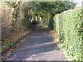
9
View NW along Chapel Lane near Carter's Clay
Image: © Nick Smith
Taken: 24 Nov 2010
0.09 miles