IMAGES TAKEN NEAR TO
Pains Hill, ROMSEY, SO51 0JE
Introduction
This page details the photographs taken nearby to Pains Hill, SO51 0JE by members of the Geograph project.
The Geograph project started in 2005 with the aim of publishing, organising and preserving representative images for every square kilometre of Great Britain, Ireland and the Isle of Man.

There are currently over 7.5m images from over14,400 individuals and you can help contribute to the project by visiting https://www.geograph.org.uk
Image Map (Loading...)


Getting Data...Please wait
Leaflet Map data © OpenStreetMap
Images are licensed for reuse under creativecommons.org/licenses/by-sa/2.0
Notes
- Clicking on the map will re-center to the selected point.
- The higher the marker number, the further away the image location is from the centre of the postcode.
Image Listing (6 Images Found)
Images are licensed for reuse under creativecommons.org/licenses/by-sa/2.0
Image
Details
Distance
1
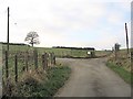
Junction of Cooks Lane with the road to Painshill Farm, Lockerley
Cooks lane is a narrow lane with few passing places which ends in a private road at this junction.
Image: © Rosemary Oakeshott
Taken: 16 Dec 2007
0.04 miles
2
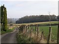
Cooks Lane, Lockerley
From the junction with road to Painshill Farm, Cooks Lane winds down to Lockerley.
Image: © Rosemary Oakeshott
Taken: 16 Dec 2007
0.11 miles
3
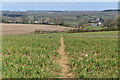
Path across field below Painshill Farm
Image: © David Martin
Taken: 22 Mar 2021
0.14 miles
4
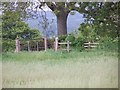
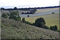
Footpaths meet under the oak at Painshill Farm
Image: © David Martin
Taken: 6 May 2007
0.17 miles
5

Painted stone on a bench
One of a series around Lockerley
Image: © David Martin
Taken: 20 Jun 2020
0.17 miles