IMAGES TAKEN NEAR TO
Cowleas Close, ROMSEY, SO51 0HQ
Introduction
This page details the photographs taken nearby to Cowleas Close, SO51 0HQ by members of the Geograph project.
The Geograph project started in 2005 with the aim of publishing, organising and preserving representative images for every square kilometre of Great Britain, Ireland and the Isle of Man.

There are currently over 7.5m images from over14,400 individuals and you can help contribute to the project by visiting https://www.geograph.org.uk
Image Map (Loading...)


Getting Data...Please wait
Leaflet Map data © OpenStreetMap
Images are licensed for reuse under creativecommons.org/licenses/by-sa/2.0
Notes
- Clicking on the map will re-center to the selected point.
- The higher the marker number, the further away the image location is from the centre of the postcode.
Image Listing (15 Images Found)
Images are licensed for reuse under creativecommons.org/licenses/by-sa/2.0
Image
Details
Distance
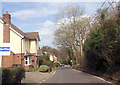
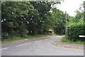
2
Junction of Saunders Lane and Cowleas Cottages
Showing Cowleas Close on the right and the houses on the west of Saunders Lane.
Image: © Rosemary Oakeshott
Taken: 31 Aug 2007
0.07 miles
3
Junction of Saunders Lane and Lockerley Road, Awbridge
Looking south towards Awbridge School which is on the corner of Danes Road and Lockerley Road.
Image: © Rosemary Oakeshott
Taken: 31 Aug 2007
0.09 miles
5
Bus shelter in Romsey Road, Awbridge
The shelter is near the junction of Danes Road and Romsey Road, which is the continuation of Lockerley Road, which is shown in the previous photo.
Image: © Rosemary Oakeshott
Taken: 31 Aug 2007
0.10 miles
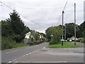
6
Crossroads in Awbridge
One of the earliest references to Awbridge (pronounced "Aybridge"), can be found in the Domesday Book. In the first draft completed in 1086, Awbridge was listed as "Abedric". By 1207 the name had changed to "Abberugge", "Abbederugge" in 1218 and "Abbederigge" by 1238. This transition reflected the Norman influence on the original Celtic name. Much later in 1849 the name was spelt "Awebridge", as can still be seen on the inscription within the northerly wall of the original chapel near Stanbridge Earls.
Originally, land in the vicinity of the hamlet of Awbridge, belonged to St Peter's Abbey, Winchester. Awbridge lies on a ridge as viewed from Michelmersh, so it is thought that its original name was "Abbodhrycg" meaning the "Ridge of the Abbot".
Image: © Patrick Pavey
Taken: 25 Jan 2007
0.10 miles
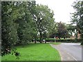
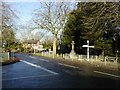
7
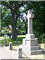
Awbridge war memorial
Just across the road junction from the village school
Image: © David Martin
Taken: 15 Jun 2008
0.11 miles
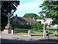
8
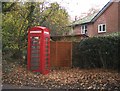
Kent's Oak Telephone Box
The phone box is in the Lockerley Road. The old post office, which can be seen behind the box, is in the road running down to Kimbridge.
Image: © Rosemary Oakeshott
Taken: 28 Nov 2007
0.11 miles
9
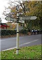
Old Direction Sign - Signpost by Romsey Road, Kent's Oak
Disc finial - 3 arms; Hampshire disc by the UC road, in parish of Awbridge (Test Valley District), junction of Saunders Lane with Romsey Road, opposite Awbridge School, Northwest of the war memorial.
To be surveyed
Milestone Society National ID: HA_SU3224B
Image: © Milestone Society
Taken: Unknown
0.11 miles
10
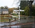
Old Direction Sign - Signpost by Romsey Road, Awbridge parish
Disc finial - 3 arms; Hampshire disc by the UC road, in parish of Awbridge (Test Valley District), junction of Danes Road and Romsey Road, opposite Awbridge School, near war memorial, by crossing barriers.
Surveyed
Milestone Society National ID: HA_SU3224A
Image: © Milestone Society
Taken: Unknown
0.12 miles