IMAGES TAKEN NEAR TO
Dunbridge Lane, ROMSEY, SO51 0GQ
Introduction
This page details the photographs taken nearby to Dunbridge Lane, SO51 0GQ by members of the Geograph project.
The Geograph project started in 2005 with the aim of publishing, organising and preserving representative images for every square kilometre of Great Britain, Ireland and the Isle of Man.

There are currently over 7.5m images from over14,400 individuals and you can help contribute to the project by visiting https://www.geograph.org.uk
Image Map (Loading...)


Getting Data...Please wait
Leaflet Map data © OpenStreetMap
Images are licensed for reuse under creativecommons.org/licenses/by-sa/2.0
Notes
- Clicking on the map will re-center to the selected point.
- The higher the marker number, the further away the image location is from the centre of the postcode.
Image Listing (9 Images Found)
Images are licensed for reuse under creativecommons.org/licenses/by-sa/2.0
Image
Details
Distance
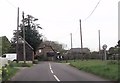
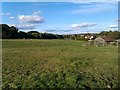
1
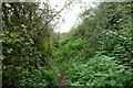
The Test Way leaving Dunbridge Lane
The start of a scratchy, stingy section of the Way
Image: © Tim Heaton
Taken: 11 Oct 2023
0.05 miles
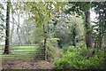
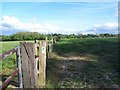
2
Stile on Test Way
A stile near Awbridge house where the Test Way leaves the road and goes into Woodland.
Image: © Patrick Pavey
Taken: 18 Apr 2007
0.05 miles
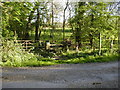
3
Path fording small stream near Awbridge House
Image: © David Martin
Taken: 5 Mar 2021
0.05 miles
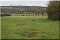
5
Farmland at Awbridge
Revisiting Image, this time in early summer.
Image: © David Martin
Taken: 23 May 2018
0.20 miles
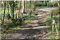
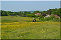
7
The Test Way crossing fields near Awbridge
Image: © David Martin
Taken: 7 May 2007
0.22 miles
8
A nettle and briar-infested section of the Test Way
Thank goodness for long trousers.
Image: © Tim Heaton
Taken: 11 Oct 2023
0.23 miles