IMAGES TAKEN NEAR TO
Ganger Farm Way, ROMSEY, SO51 0EE
Introduction
This page details the photographs taken nearby to Ganger Farm Way, SO51 0EE by members of the Geograph project.
The Geograph project started in 2005 with the aim of publishing, organising and preserving representative images for every square kilometre of Great Britain, Ireland and the Isle of Man.

There are currently over 7.5m images from over14,400 individuals and you can help contribute to the project by visiting https://www.geograph.org.uk
Image Map
Images are licensed for reuse under creativecommons.org/licenses/by-sa/2.0
Notes
- Clicking on the map will re-center to the selected point.
- The higher the marker number, the further away the image location is from the centre of the postcode.
Image Listing (7 Images Found)
Images are licensed for reuse under creativecommons.org/licenses/by-sa/2.0
Image
Details
Distance
1
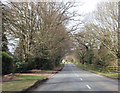
Thunderstorm approaching Ganger Farm Way
New housing development on the outskirts of Romsey.
Image: © David Martin
Taken: 23 Oct 2022
0.16 miles
2
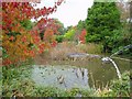
Sir Harold Hillier Gardens & Arboretum
The lake is just one small feature of this beautiful garden.
Image: © Al Menzies
Taken: 22 Oct 2004
0.17 miles
4
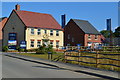
Show homes at Kings Chase development
The lack of apostrophe in the name reflects the developer's usage.
Image: © David Martin
Taken: 28 Jul 2019
0.19 miles
5
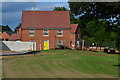
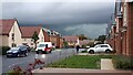
New housing close to Ganger Farm
Houses nearing completion on the edge of the Kings Chase development.
Image: © David Martin
Taken: 28 Jul 2019
0.20 miles
6
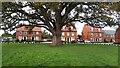
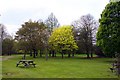
Tree and green in centre of Walnut Close
Image: © David Martin
Taken: 27 Oct 2022
0.23 miles