IMAGES TAKEN NEAR TO
Mortimer Drive, ROMSEY, SO51 0ED
Introduction
This page details the photographs taken nearby to Mortimer Drive, SO51 0ED by members of the Geograph project.
The Geograph project started in 2005 with the aim of publishing, organising and preserving representative images for every square kilometre of Great Britain, Ireland and the Isle of Man.

There are currently over 7.5m images from over14,400 individuals and you can help contribute to the project by visiting https://www.geograph.org.uk
Image Map (Loading...)


Getting Data...Please wait
Leaflet Map data © OpenStreetMap
Images are licensed for reuse under creativecommons.org/licenses/by-sa/2.0
Notes
- Clicking on the map will re-center to the selected point.
- The higher the marker number, the further away the image location is from the centre of the postcode.
Image Listing (7 Images Found)
Images are licensed for reuse under creativecommons.org/licenses/by-sa/2.0
Image
Details
Distance
1
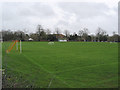
Playing Fields at Stanbridge Earls School, nr Romsey
The school specialises in pupils with learning difficulties. http://www.stanbridgeearls.hants.sch.uk/
Image: © Peter Facey
Taken: 30 Dec 2006
0.10 miles
2
Footpath by entrance to Parsonage Farm
This path leads across fields to the B3084 near Stanbridge Earls School
Image: © David Martin
Taken: 30 May 2009
0.12 miles
3

Cooks Lane junction with Stanbridge Lane
Image: © Stuart Logan
Taken: 18 Mar 2012
0.13 miles
4
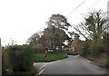
Cooks Lane junction with Stanbridge Lane
This is the junction where the post box is situated. Cooks Lane has 2 junctions with Stanbridge Lane
Image: © John Firth
Taken: 2 Apr 2014
0.15 miles
5
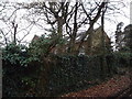
Former Congregational Chapel, Awbridge
Erected in 1810. Now converted into a private residence.
Image: © Michael FORD
Taken: Unknown
0.18 miles
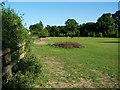
6
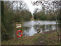
Lake at Stanbridge Earls School
There are three lakes here running into each other. This is the upper one.
Image: © Peter Facey
Taken: 30 Dec 2006
0.22 miles
7
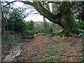
Stream feeding lakes at Stanbridge Earls School, nr Romsey
Just upstream from footpath.
Image: © Peter Facey
Taken: 30 Dec 2006
0.24 miles