IMAGES TAKEN NEAR TO
Wadham Close, ROMSEY, SO51 0AN
Introduction
This page details the photographs taken nearby to Wadham Close, SO51 0AN by members of the Geograph project.
The Geograph project started in 2005 with the aim of publishing, organising and preserving representative images for every square kilometre of Great Britain, Ireland and the Isle of Man.

There are currently over 7.5m images from over14,400 individuals and you can help contribute to the project by visiting https://www.geograph.org.uk
Image Map (Loading...)


Getting Data...Please wait
Leaflet Map data © OpenStreetMap
Images are licensed for reuse under creativecommons.org/licenses/by-sa/2.0
Notes
- Clicking on the map will re-center to the selected point.
- The higher the marker number, the further away the image location is from the centre of the postcode.
Image Listing (17 Images Found)
Images are licensed for reuse under creativecommons.org/licenses/by-sa/2.0
Image
Details
Distance
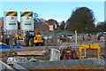
1
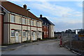
New homes nearing completion in the Abbotswood development
A 52.4 hectare site which will contain 800 new homes on the edge of Romsey.
Image: © David Martin
Taken: 13 Jan 2013
0.11 miles
3
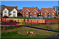
Children's playground and new housing, Abbotswood
This crescent of larger detached houses at the edge of the playground is a central feature of the new development.
Image: © David Martin
Taken: 23 Mar 2014
0.12 miles
4
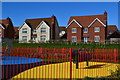
Brightly coloured playground surfaces, Abbotswood
This crescent of larger detached houses at the edge of the playground is a central feature of the new development.
Image: © David Martin
Taken: 23 Mar 2014
0.12 miles
5

Mixed textures on new housing at Abbotswood
A variety of styles displayed in a single structure on the Abbotswood development at Romsey.
Image: © David Martin
Taken: 23 Mar 2014
0.16 miles
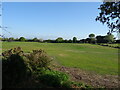

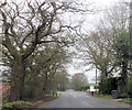
10

Woodley Cemetery, Romsey
The north-west corner of the cemetery near the road. The white van is driving towards Belbins.
Image: © Rosemary Oakeshott
Taken: 7 Dec 2007
0.19 miles