IMAGES TAKEN NEAR TO
Tilebourne Close, ROMSEY, SO51 0AH
Introduction
This page details the photographs taken nearby to Tilebourne Close, SO51 0AH by members of the Geograph project.
The Geograph project started in 2005 with the aim of publishing, organising and preserving representative images for every square kilometre of Great Britain, Ireland and the Isle of Man.

There are currently over 7.5m images from over14,400 individuals and you can help contribute to the project by visiting https://www.geograph.org.uk
Image Map (Loading...)


Getting Data...Please wait
Leaflet Map data © OpenStreetMap
Images are licensed for reuse under creativecommons.org/licenses/by-sa/2.0
Notes
- Clicking on the map will re-center to the selected point.
- The higher the marker number, the further away the image location is from the centre of the postcode.
Image Listing (15 Images Found)
Images are licensed for reuse under creativecommons.org/licenses/by-sa/2.0
Image
Details
Distance
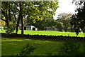
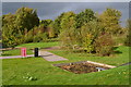
1
Houses at Casbrook Field, seen from the play area
Image: © David Martin
Taken: 21 Oct 2017
0.03 miles
2
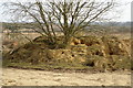
Bunny Heaven, Casbrook Common
Judging by the tree the sand has been dumped rather than excavated here, on the edge of a vast refuse site.
Image: © Pierre Terre
Taken: 23 Mar 2006
0.05 miles
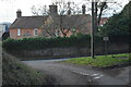
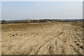
5
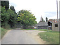
Land north of Hunts Farm
View south along Rudd Lane towards Hunts Farm
Image: © Pierre Terre
Taken: 23 Mar 2006
0.17 miles
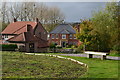
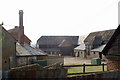
6
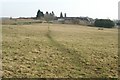
Hunt's Farm
Looking S from Michelmersh
Image: © Pierre Terre
Taken: 23 Mar 2006
0.17 miles
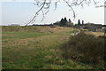
8
Casbrook Common
A levelled landfill site
Image: © Pierre Terre
Taken: 23 Mar 2006
0.18 miles