IMAGES TAKEN NEAR TO
Jerrems Hill, ROMSEY, SO51 0AB
Introduction
This page details the photographs taken nearby to Jerrems Hill, SO51 0AB by members of the Geograph project.
The Geograph project started in 2005 with the aim of publishing, organising and preserving representative images for every square kilometre of Great Britain, Ireland and the Isle of Man.

There are currently over 7.5m images from over14,400 individuals and you can help contribute to the project by visiting https://www.geograph.org.uk
Image Map (Loading...)


Getting Data...Please wait
Leaflet Map data © OpenStreetMap
Images are licensed for reuse under creativecommons.org/licenses/by-sa/2.0
Notes
- Clicking on the map will re-center to the selected point.
- The higher the marker number, the further away the image location is from the centre of the postcode.
Image Listing (10 Images Found)
Images are licensed for reuse under creativecommons.org/licenses/by-sa/2.0
Image
Details
Distance
2
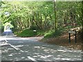
Spearywell Road, Mottisfont
This is the road just before you enter Spearywell Wood behind me. Back Lane is on the right. The Mottisfont footpath continues down this road on the right hand side.
Image: © Gillian Thomas
Taken: 26 Apr 2007
0.08 miles
3
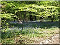
Bluebells in Great Copse
Great Copse is a semi-natural ancient copse. An ancient copse is over 400 years old and this is semi-natural as it has been managed.
Image: © Gillian Thomas
Taken: 26 Apr 2007
0.08 miles
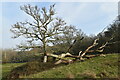
4
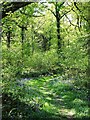
Great Copse, Mottisfont
This wonderful little copse is full of bluebells in April.
Image: © Gillian Thomas
Taken: 26 Apr 2007
0.11 miles
5
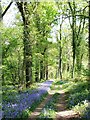
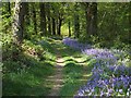
Footpath through Great Copse
The footpath here is at present lined with bluebells.
Image: © Gillian Thomas
Taken: 26 Apr 2007
0.12 miles
7
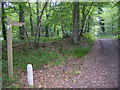
The Mottisfont Waymark as you enter Spearywell Wood
As you follow the side of the meadow you suddenly arrive in the woodland.
Image: © Gillian Thomas
Taken: 26 Apr 2007
0.21 miles
9

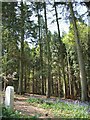
Footpath into Spearywell Wood
The meadow with the thatched cottage is on the left of this picture.
Image: © Gillian Thomas
Taken: 26 Apr 2007
0.23 miles
10

B3084 passes Newlyns Farm
The 19th C. brick built farmhouse has a Grade II listing and English Heritage Building ID: 140956.
Image: © Stuart Logan
Taken: 13 Jun 2014
0.24 miles