IMAGES TAKEN NEAR TO
Leah Gardens, EASTLEIGH, SO50 9QX
Introduction
This page details the photographs taken nearby to Leah Gardens, SO50 9QX by members of the Geograph project.
The Geograph project started in 2005 with the aim of publishing, organising and preserving representative images for every square kilometre of Great Britain, Ireland and the Isle of Man.

There are currently over 7.5m images from over14,400 individuals and you can help contribute to the project by visiting https://www.geograph.org.uk
Image Map
Images are licensed for reuse under creativecommons.org/licenses/by-sa/2.0
Notes
- Clicking on the map will re-center to the selected point.
- The higher the marker number, the further away the image location is from the centre of the postcode.
Image Listing (91 Images Found)
Images are licensed for reuse under creativecommons.org/licenses/by-sa/2.0
Image
Details
Distance
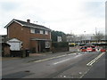
2
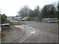
Heavy plant stored near Woodside Allotments
Image: © Basher Eyre
Taken: 12 Dec 2009
0.04 miles
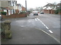
4
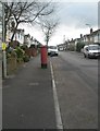
Junction of Meynell Close and Kipling Road
Image: © Basher Eyre
Taken: 12 Dec 2009
0.05 miles
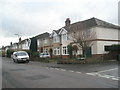
5
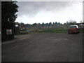
Southampton & District Motorcycle Club HQ
Image: © Basher Eyre
Taken: 12 Dec 2009
0.05 miles
6
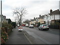
Approaching the junction of Kipling Road and Meynell Close
Image: © Basher Eyre
Taken: 12 Dec 2009
0.06 miles

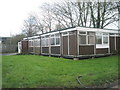
9
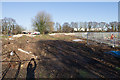
Site for housing development beside Woodside Avenue
This site has recently been cleared. In the distance a recently-closed Household Waste Recycling Centre. Off-picture right the allotments.
Image: © Peter Facey
Taken: 29 Dec 2016
0.06 miles