IMAGES TAKEN NEAR TO
Strawberry Mead, EASTLEIGH, SO50 8RH
Introduction
This page details the photographs taken nearby to Strawberry Mead, SO50 8RH by members of the Geograph project.
The Geograph project started in 2005 with the aim of publishing, organising and preserving representative images for every square kilometre of Great Britain, Ireland and the Isle of Man.

There are currently over 7.5m images from over14,400 individuals and you can help contribute to the project by visiting https://www.geograph.org.uk
Image Map
Images are licensed for reuse under creativecommons.org/licenses/by-sa/2.0
Notes
- Clicking on the map will re-center to the selected point.
- The higher the marker number, the further away the image location is from the centre of the postcode.
Image Listing (23 Images Found)
Images are licensed for reuse under creativecommons.org/licenses/by-sa/2.0
Image
Details
Distance
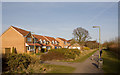
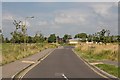
2
Path across Strawberry Mead
Looking from footpath along the southern edge of this newish development, along a path between the houses in Strawberry Mead, towards the green at the centre of Damson Crescent.
Image: © Peter Facey
Taken: 16 Mar 2010
0.08 miles
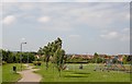
3
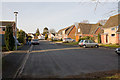
Greens Close
Seen from its southern, closed, end.
Image: © Peter Facey
Taken: 16 Mar 2010
0.10 miles
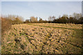
4
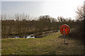
Pond in rough land south of Strawberry Mead
Image: © Peter Facey
Taken: 16 Mar 2010
0.11 miles
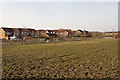
5
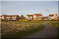
Houses in Strawberry Mead
Seen from footpath running along the southern edge of this newish development.
Image: © Peter Facey
Taken: 16 Mar 2010
0.12 miles
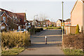
7
Path from Fairoak Road to Damson Crescent
The housing here has been built within the poast five years.
Image: © Peter Facey
Taken: 23 Jul 2008
0.14 miles
8
Backs of houses in Damson Crescent
Seen from footpath.
Image: © Peter Facey
Taken: 16 Mar 2010
0.14 miles
9
Blackberry Drive
Providing access to housing in Damson Crescent. This was formerly a continuation of Sandy Lane but has now been renamed following the building of the housing.
Image: © Peter Facey
Taken: 23 Jul 2008
0.16 miles
10
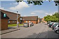
Stokewood Surgery, Stoke Wood Close
This small cul de sac has a pharmacy and surgery here and, beyond, some housing.
Image: © Peter Facey
Taken: 23 Jul 2008
0.18 miles