IMAGES TAKEN NEAR TO
Hartley Road, EASTLEIGH, SO50 8JB
Introduction
This page details the photographs taken nearby to Hartley Road, SO50 8JB by members of the Geograph project.
The Geograph project started in 2005 with the aim of publishing, organising and preserving representative images for every square kilometre of Great Britain, Ireland and the Isle of Man.

There are currently over 7.5m images from over14,400 individuals and you can help contribute to the project by visiting https://www.geograph.org.uk
Image Map
Images are licensed for reuse under creativecommons.org/licenses/by-sa/2.0
Notes
- Clicking on the map will re-center to the selected point.
- The higher the marker number, the further away the image location is from the centre of the postcode.
Image Listing (15 Images Found)
Images are licensed for reuse under creativecommons.org/licenses/by-sa/2.0
Image
Details
Distance
1
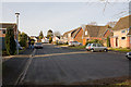
Greens Close
Seen from its southern, closed, end.
Image: © Peter Facey
Taken: 16 Mar 2010
0.14 miles
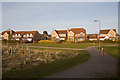
2
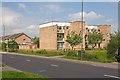
Badger Court, Fairoak Road
A small block of flats.
Image: © Peter Facey
Taken: 23 Jul 2008
0.16 miles
6
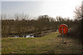
Pond in rough land south of Strawberry Mead
Image: © Peter Facey
Taken: 16 Mar 2010
0.21 miles
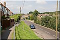
7
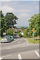
Looking along Fairoak Road from its junction with Alan Drayton Way
Image: © Peter Facey
Taken: 23 Jul 2008
0.21 miles
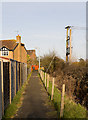
8
Elevated pavement on south side of Fairoak Road
Image: © Peter Facey
Taken: 23 Jul 2008
0.21 miles
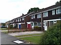
9
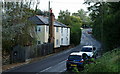
Cottages on Fairoak Road, Bishopstoke, Hampshire
A pair of Victorian cottages, overlooked, by housing, from the opposite side of the road.
Image: © Peter Trimming
Taken: 17 Oct 2012
0.21 miles