IMAGES TAKEN NEAR TO
Whalesmead Road, EASTLEIGH, SO50 8HL
Introduction
This page details the photographs taken nearby to Whalesmead Road, SO50 8HL by members of the Geograph project.
The Geograph project started in 2005 with the aim of publishing, organising and preserving representative images for every square kilometre of Great Britain, Ireland and the Isle of Man.

There are currently over 7.5m images from over14,400 individuals and you can help contribute to the project by visiting https://www.geograph.org.uk
Image Map
Images are licensed for reuse under creativecommons.org/licenses/by-sa/2.0
Notes
- Clicking on the map will re-center to the selected point.
- The higher the marker number, the further away the image location is from the centre of the postcode.
Image Listing (19 Images Found)
Images are licensed for reuse under creativecommons.org/licenses/by-sa/2.0
Image
Details
Distance
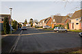
2
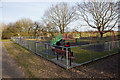
Children's Play Area south of Templecombe Road
With a couple of teenagers chilling out.
Image: © Peter Facey
Taken: 16 Mar 2010
0.13 miles

5
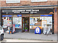
Whales mead Post Office & General Stores, Fairoak Road
Image: © Peter Facey
Taken: 23 Jul 2008
0.20 miles
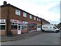
6
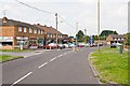
Shops on corner of Fairoak Road and Whalesmead Road
Image: © Peter Facey
Taken: 23 Jul 2008
0.21 miles
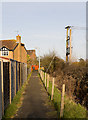
7
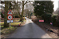
West Horton Lane
A private lane leading to West Horton Farm and industrial estate.
Image: © Peter Facey
Taken: 16 Mar 2010
0.21 miles

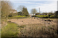
10
Greens Close
Seen from its southern, closed, end.
Image: © Peter Facey
Taken: 16 Mar 2010
0.22 miles