IMAGES TAKEN NEAR TO
Kingsmill Drive, EASTLEIGH, SO50 7QE
Introduction
This page details the photographs taken nearby to Kingsmill Drive, SO50 7QE by members of the Geograph project.
The Geograph project started in 2005 with the aim of publishing, organising and preserving representative images for every square kilometre of Great Britain, Ireland and the Isle of Man.

There are currently over 7.5m images from over14,400 individuals and you can help contribute to the project by visiting https://www.geograph.org.uk
Image Map
Images are licensed for reuse under creativecommons.org/licenses/by-sa/2.0
Notes
- Clicking on the map will re-center to the selected point.
- The higher the marker number, the further away the image location is from the centre of the postcode.
Image Listing (22 Images Found)
Images are licensed for reuse under creativecommons.org/licenses/by-sa/2.0
Image
Details
Distance
1
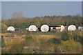
Satellite Communication station, Knowle Lane, Fair Oak
This seems to be operated by Sky TV and I presume it is a satellite uplink station although it might possibly be for more general purpose telecommunication.
Image: © Peter Facey
Taken: 8 Apr 2007
0.05 miles
2

Sky Satellite teleport, Knowle Lane
For a more distant view of this teleport, see Image
Image: © Peter Facey
Taken: 28 Feb 2009
0.08 miles
3
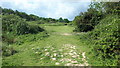
Deer Park Farm access road, Fair Oak
Looking along it at its junction with Knowle Lane. On the right is the entrance to a household waste recycling centre. Beyond Knowle Lane is a satellite teleport.
Image: © Peter Facey
Taken: 28 Feb 2009
0.10 miles
4
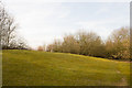
Viewing Mound at Knowle Hill, Fair Oak
For explanation, see Image
Image: © Peter Facey
Taken: 28 Feb 2009
0.11 miles
5
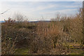
View from Knowle Hill viewing mound, Fair Oak
Knowle Hill is an area of grass and scrub with a small pond. A notice by Fair Oak and Horton Heath Parish Council says "The site was originally an old sand pit, and then a rubbish dump, and is now open for people to enjoy". "The viewing mound was created from a pile of waste rubble. Climb up to the top and you'll have excellent views of Stoke Park woods". However, unless the scrub seen in this photo is cleared, this claim would seem to be a bit optimistic for anyone under ten feet tall. See also Image
Image: © Peter Facey
Taken: 28 Feb 2009
0.12 miles
6
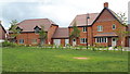
Newly built housing near the top of Knowle Lane
Recent housing in an area currently seeing massive residential expansion.
Image: © David Martin
Taken: 3 Jun 2019
0.12 miles
7
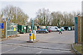
Household Waste Recycling Centre, Knowle Lane
Provided by Hampshire County Council.
Image: © Peter Facey
Taken: 28 Feb 2009
0.13 miles
8
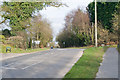
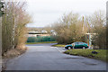
Knowle Lane joins Mortimers Lane
Knowle Lane is the turning on the right. It is frequently used due to there being a Hampshire County Council household waste recycling centre there.
Image: © Peter Facey
Taken: 28 Feb 2009
0.14 miles
9
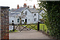
Number 79, Mortimers Lane, Fair Oak
In spite of its banal name, it appears this is one of the older properties in the lane.
Image: © Peter Facey
Taken: 28 Feb 2009
0.15 miles