IMAGES TAKEN NEAR TO
Bramley Gardens, EASTLEIGH, SO50 7QB
Introduction
This page details the photographs taken nearby to Bramley Gardens, SO50 7QB by members of the Geograph project.
The Geograph project started in 2005 with the aim of publishing, organising and preserving representative images for every square kilometre of Great Britain, Ireland and the Isle of Man.

There are currently over 7.5m images from over14,400 individuals and you can help contribute to the project by visiting https://www.geograph.org.uk
Image Map
Images are licensed for reuse under creativecommons.org/licenses/by-sa/2.0
Notes
- Clicking on the map will re-center to the selected point.
- The higher the marker number, the further away the image location is from the centre of the postcode.
Image Listing (39 Images Found)
Images are licensed for reuse under creativecommons.org/licenses/by-sa/2.0
Image
Details
Distance
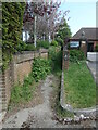
1
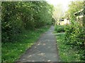
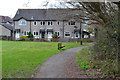
Footpath along Burnetts Lane, Horton Heath
Separated from the road by a line of trees, with paths going off into the estate served by Meadowsweet Way.
Image: © Christine Johnstone
Taken: 23 Apr 2022
0.05 miles
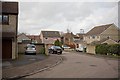
2
Bryony Gardens and Meadowsweet Way
All the roads in this Horton Heath estate are named after flowers.
Image: © Christine Johnstone
Taken: 23 Apr 2022
0.06 miles
3
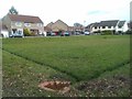
Grassed area, Meadowsweet Way
The low level of the central area and the surrounding drainage channels suggest that it may also have a function as a balancing pond in times of high rainfall.
Image: © David Martin
Taken: 10 Mar 2012
0.07 miles
4
Boggy area south of Angelica Gardens
Seen from footpath. A stream runs through this.
Image: © Peter Facey
Taken: 25 May 2016
0.07 miles
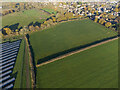
7

Site of proposed primary school
Aerial. In the field ahead left, beyond the solar farm. Planned to open in 2027 and take 630 children. To the right of the hedge is the site of the proposed sports field. Existing housing seen beyond is in Horton Heath. See also https://www.geograph.org.uk/photo/7354003 .
Image: © Peter Facey
Taken: 1 Dec 2022
0.12 miles
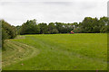
8
Site of proposed primary school
Aerial. Beyond the hedge. Planned to open in 2027 and take 630 children. See also https://www.geograph.org.uk/photo/7353987 . The field on the near side of the hedge is proposed to become a sports field. Existing housing top right adjoining this field is in Angelica Gardens and Bramley Gardens, Horton Heath.
Image: © Peter Facey
Taken: 1 Dec 2022
0.12 miles
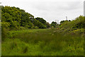
9
Field west of Angelica Gardens
Being mown. I failed to notice but assume it is some kind of public recreation area.
Image: © Peter Facey
Taken: 25 May 2016
0.15 miles
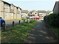
10
Public footpath, St Andrews Park, Horton Heath
With a warning about CCTV, but not about the nettles!
Image: © Christine Johnstone
Taken: 23 Apr 2022
0.16 miles