IMAGES TAKEN NEAR TO
Longfield Road, EASTLEIGH, SO50 7LX
Introduction
This page details the photographs taken nearby to Longfield Road, SO50 7LX by members of the Geograph project.
The Geograph project started in 2005 with the aim of publishing, organising and preserving representative images for every square kilometre of Great Britain, Ireland and the Isle of Man.

There are currently over 7.5m images from over14,400 individuals and you can help contribute to the project by visiting https://www.geograph.org.uk
Image Map
Images are licensed for reuse under creativecommons.org/licenses/by-sa/2.0
Notes
- Clicking on the map will re-center to the selected point.
- The higher the marker number, the further away the image location is from the centre of the postcode.
Image Listing (84 Images Found)
Images are licensed for reuse under creativecommons.org/licenses/by-sa/2.0
Image
Details
Distance
1
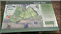
Map board in Knowle Park
A nice information board, but with a geographical error: the north arrow does not correspond to north on the map! (Looks more like northwest)
Image: © David Martin
Taken: 3 Jun 2019
0.13 miles
3
Mortimers Lane approaching Willow Grove
Willow Grove is the turning on the right beyond the cyclist. This short section of bollards affords, I presume, additional protection for pedestrians against traffic that can't be bothered to follow the Lane as it bends to the left.
Image: © Peter Facey
Taken: 28 Feb 2009
0.14 miles
4
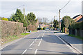
Mortimers Lane, Fair Oak
Approaching Mortimers Drive on right. This is the B3037 from Fair Oak to Lower Upham. There are residential closes off both sides of this road.
Image: © Peter Facey
Taken: 28 Feb 2009
0.15 miles
5
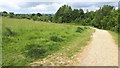
White Tree Close turning for Knowle Park
Image: © John Firth
Taken: 15 Apr 2013
0.16 miles
6
"The Old George" Fair Oak Square.
Photo taken from roughly the same position as historic photo of subject in Francis Frith's Around Eastleigh, Living Memories book.
Image: © Rob Byrne
Taken: 5 Feb 2006
0.17 miles
7
Eastleigh Road junction Fair Oak
From Botley Road
Image: © John Firth
Taken: 15 Apr 2013
0.18 miles
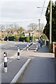
8
Pedestrian entrance to Wyvern Technology College, Fairoak
Image: © Peter Facey
Taken: 30 Mar 2008
0.18 miles
9
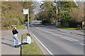
Bus stop on Mortimers Lane, Fair Oak
Between Hall Lands Lane and Pembers Close (the turning beyond on the left).
Image: © Peter Facey
Taken: 28 Feb 2009
0.18 miles
10
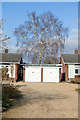
Westfield, Mortimers Lane
The bungalow on the left is number 30 named Westfield. A fine Silver Birch tree is in the garden of this or the adjacent bungalow.
Image: © Peter Facey
Taken: 28 Feb 2009
0.18 miles