IMAGES TAKEN NEAR TO
Davidson Drive, EASTLEIGH, SO50 7HX
Introduction
This page details the photographs taken nearby to Davidson Drive, SO50 7HX by members of the Geograph project.
The Geograph project started in 2005 with the aim of publishing, organising and preserving representative images for every square kilometre of Great Britain, Ireland and the Isle of Man.

There are currently over 7.5m images from over14,400 individuals and you can help contribute to the project by visiting https://www.geograph.org.uk
Image Map
Images are licensed for reuse under creativecommons.org/licenses/by-sa/2.0
Notes
- Clicking on the map will re-center to the selected point.
- The higher the marker number, the further away the image location is from the centre of the postcode.
Image Listing (31 Images Found)
Images are licensed for reuse under creativecommons.org/licenses/by-sa/2.0
Image
Details
Distance
1
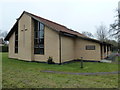
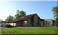
St Swithun Wells, Fair Oak
For more information about this saint see http://en.wikipedia.org/wiki/St._Swithun_Wells
Image: © Basher Eyre
Taken: 28 Feb 2013
0.03 miles
3
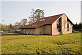
St Swithun Wells Catholic Church, Allington Lane
See http://www.stswithunwellsparish.org.uk/
Image: © Peter Facey
Taken: 16 Mar 2010
0.07 miles
4
St Swithun Wells Catholic Church, Allington Lane
See http://www.stswithunwellsparish.org.uk/
Image: © Peter Facey
Taken: 16 Mar 2010
0.07 miles
5
St Swithun Wells Catholic Church on Allington Lane
Image: © JThomas
Taken: 29 Apr 2022
0.07 miles
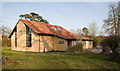
6
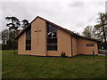
St Swithun Wells Roman Catholic Church, Fair Oak
In Allington Lane.
Image: © Michael FORD
Taken: Unknown
0.07 miles
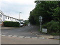
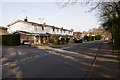
10
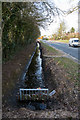
Ditch beside Allington Lane
Recently cleaned out.
Image: © Peter Facey
Taken: 16 Mar 2010
0.09 miles