IMAGES TAKEN NEAR TO
Rustan Close, EASTLEIGH, SO50 7HL
Introduction
This page details the photographs taken nearby to Rustan Close, SO50 7HL by members of the Geograph project.
The Geograph project started in 2005 with the aim of publishing, organising and preserving representative images for every square kilometre of Great Britain, Ireland and the Isle of Man.

There are currently over 7.5m images from over14,400 individuals and you can help contribute to the project by visiting https://www.geograph.org.uk
Image Map
Images are licensed for reuse under creativecommons.org/licenses/by-sa/2.0
Notes
- Clicking on the map will re-center to the selected point.
- The higher the marker number, the further away the image location is from the centre of the postcode.
Image Listing (18 Images Found)
Images are licensed for reuse under creativecommons.org/licenses/by-sa/2.0
Image
Details
Distance
1
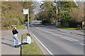
Bus stop on Mortimers Lane, Fair Oak
Between Hall Lands Lane and Pembers Close (the turning beyond on the left).
Image: © Peter Facey
Taken: 28 Feb 2009
0.05 miles
2
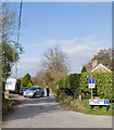
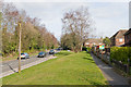
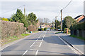
Mortimers Lane approaching Willow Grove
The sinuous nature of the B3037 is easily seen on the ground but hardly apparent at all on maps.
Image: © Peter Facey
Taken: 28 Feb 2009
0.05 miles
3
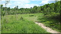
Hall Lands Lane, Fair Oak
A private tarmac road to Hall Lands Farm which is also a public footpath.
Image: © Peter Facey
Taken: 28 Feb 2009
0.07 miles
4
Mortimers Lane, Fair Oak
Approaching Scotland Close (next turning on right). The houses and pavement on the right are here at a level above the road.
Image: © Peter Facey
Taken: 28 Feb 2009
0.09 miles
5
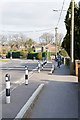
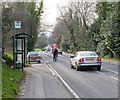
Mortimers Lane approaching Willow Grove
Willow Grove is the turning on the right beyond the cyclist. This short section of bollards affords, I presume, additional protection for pedestrians against traffic that can't be bothered to follow the Lane as it bends to the left.
Image: © Peter Facey
Taken: 28 Feb 2009
0.11 miles
6
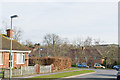
Scotland Close, off Mortimer Lane
Some distance beyond you can see the tops of buildings in Deer Park Farm Industrial Estate.
Image: © Peter Facey
Taken: 28 Feb 2009
0.12 miles
7
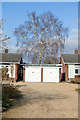
Westfield, Mortimers Lane
The bungalow on the left is number 30 named Westfield. A fine Silver Birch tree is in the garden of this or the adjacent bungalow.
Image: © Peter Facey
Taken: 28 Feb 2009
0.14 miles
8
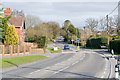
Mortimers Lane, Fair Oak
Approaching Mortimers Drive on right. This is the B3037 from Fair Oak to Lower Upham. There are residential closes off both sides of this road.
Image: © Peter Facey
Taken: 28 Feb 2009
0.15 miles
9
Mortimers Lane, Fair Oak
Approaching Camelia Grove (on right).
Image: © Peter Facey
Taken: 28 Feb 2009
0.17 miles