IMAGES TAKEN NEAR TO
Winchester Road, EASTLEIGH, SO50 7GU
Introduction
This page details the photographs taken nearby to Winchester Road, SO50 7GU by members of the Geograph project.
The Geograph project started in 2005 with the aim of publishing, organising and preserving representative images for every square kilometre of Great Britain, Ireland and the Isle of Man.

There are currently over 7.5m images from over14,400 individuals and you can help contribute to the project by visiting https://www.geograph.org.uk
Image Map
Images are licensed for reuse under creativecommons.org/licenses/by-sa/2.0
Notes
- Clicking on the map will re-center to the selected point.
- The higher the marker number, the further away the image location is from the centre of the postcode.
Image Listing (83 Images Found)
Images are licensed for reuse under creativecommons.org/licenses/by-sa/2.0
Image
Details
Distance
1
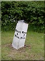
Old Milepost by the B3354, Winchester Road, Fair Oak and Horton Heath parish
Cast iron post by the B3354, Fair Oak and Horton Heath parish (Eastleigh District), North of Summerlands Road, on East side of road. Botley tri-post erected by the Lower St Cross, Mill Lane to Park Gate Turnpike Trust in the 19th century.
Inscription reads:-
: BOTLEY / 4 / MILES : : WINTON / 7 / MILES :
Milestone Society National ID: HA_BOWI04
Image: © K Lawrence
Taken: 18 May 2003
0.04 miles
2
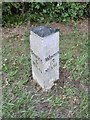
Milepost, Fair Oak
Cast iron post by the B3354, Fair Oak and Horton Heath (Eastleigh District). Fair Oak, 50m South of junction with Summerlands Road, on East side of road. Botley tri-post erected by the Lower St Cross, Mill Lane to Park Gate Turnpike Trust in the 19th century.
The inscription reads: BOTLEY / 4 MILES // WINTON / 7 / MILES //
Not listed by Historic England.
Milestone Society National ID: HA_BOWI04
Image: © Mike Faherty
Taken: 15 Aug 2020
0.04 miles

5
Mortimers Lane approaches Botley Road, Fair Oak
This is the B3037 about to join the B3354 at a T-junction beyond the blue car. On the right is the road named Glebe Court.
Image: © Peter Facey
Taken: 28 Feb 2009
0.14 miles

7
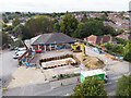
Tesco Express filling station refurbishment
Aerial. Showing newly installed underground tanks.
Image: © Peter Facey
Taken: 3 Oct 2022
0.17 miles
8
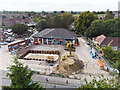
Tesco Express filling station refurbishment
Aerial. Showing newly installed underground tanks.
Image: © Peter Facey
Taken: 3 Oct 2022
0.17 miles
9
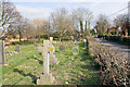
Pember Churchyard, Fair Oak
Managed by Fair Oak and Horton Heath Parish Council in such a way as to encourage wildlife. Next to St. Thomas' Church.
Image: © Peter Facey
Taken: 28 Feb 2009
0.18 miles
10
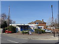
Public Library, Fair Oak: mid March 2013
Image: © Basher Eyre
Taken: 13 Mar 2014
0.18 miles