IMAGES TAKEN NEAR TO
Chiltern Crescent, EASTLEIGH, SO50 7GJ
Introduction
This page details the photographs taken nearby to Chiltern Crescent, SO50 7GJ by members of the Geograph project.
The Geograph project started in 2005 with the aim of publishing, organising and preserving representative images for every square kilometre of Great Britain, Ireland and the Isle of Man.

There are currently over 7.5m images from over14,400 individuals and you can help contribute to the project by visiting https://www.geograph.org.uk
Image Map
Images are licensed for reuse under creativecommons.org/licenses/by-sa/2.0
Notes
- Clicking on the map will re-center to the selected point.
- The higher the marker number, the further away the image location is from the centre of the postcode.
Image Listing (48 Images Found)
Images are licensed for reuse under creativecommons.org/licenses/by-sa/2.0
Image
Details
Distance
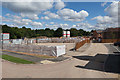
1

Phase 3 building site of Crowdhill Green housing development
Seen from Crowdhill Copse which is Woodland Trust property. Site drainage ditch in foreground.
Image: © Peter Facey
Taken: 31 Jul 2016
0.05 miles
2
Bloor Homes compound, Crowdhill Green housing development
From which phase 3 (beyond and left) is being built.
Image: © Peter Facey
Taken: 31 Jul 2016
0.08 miles
3

Phase 3 building site of Crowdhill Green housing development
Seen from Crowdhill Copse which is Woodland Trust property. Site drainage pond in the foreground. Elevated camera position.
Image: © Peter Facey
Taken: 31 Jul 2016
0.08 miles
4

Phase 3 building site of Crowdhill Green housing development
For a wider view see http://www.geograph.org.uk/photo/5057446
Image: © Peter Facey
Taken: 31 Jul 2016
0.09 miles
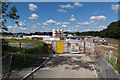
5

Sign for affordable housing in Crowdhill Green housing development
Being built by the housing association Stonewater with funding from the Homes & Communities Agency and working in partnership with Eastleigh Borough Council. A development of 11 homes for affordable rent and shared ownership, and two 2 bed and one 3 bed homes for shared ownership sale.
Image: © Peter Facey
Taken: 31 Jul 2016
0.11 miles
6

Savernake Way, Crowdhill Green housing development
Seen from its present western end, it being closed off berhind the camera whilst phase 3 is built. The affordable housing is accessed via the road at right.
Image: © Peter Facey
Taken: 31 Jul 2016
0.12 miles
7

Path from Kinver Crescent to phase 3 of Crowdhill Green housing development
Image: © Peter Facey
Taken: 31 Jul 2016
0.13 miles
8
Linden Homes compound, Crowdhill Housing development
From which they are building phase 2 of this development, to the north of Savernake Way. Elevated camera position.
Image: © Peter Facey
Taken: 31 Jul 2016
0.13 miles
9

Part of Kinver Crescent, Crowdhill Green housing development
Both ends of the Crescent are on Savernake Way.
Image: © Peter Facey
Taken: 31 Jul 2016
0.15 miles
10

Phase 3 building site of Crowdhill Green housing development
Being built by Bloor Homes. For a closer view see http://www.geograph.org.uk/photo/5057450
Image: © Peter Facey
Taken: 31 Jul 2016
0.15 miles