IMAGES TAKEN NEAR TO
Witt Road, EASTLEIGH, SO50 7FN
Introduction
This page details the photographs taken nearby to Witt Road, SO50 7FN by members of the Geograph project.
The Geograph project started in 2005 with the aim of publishing, organising and preserving representative images for every square kilometre of Great Britain, Ireland and the Isle of Man.

There are currently over 7.5m images from over14,400 individuals and you can help contribute to the project by visiting https://www.geograph.org.uk
Image Map
Images are licensed for reuse under creativecommons.org/licenses/by-sa/2.0
Notes
- Clicking on the map will re-center to the selected point.
- The higher the marker number, the further away the image location is from the centre of the postcode.
Image Listing (23 Images Found)
Images are licensed for reuse under creativecommons.org/licenses/by-sa/2.0
Image
Details
Distance
1
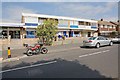
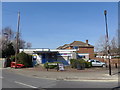
Shops on Sandy Lane
These shops, probably built in the 1960s, are, in my view, badly laid out. They face directly onto the street with pointless hard landscaping in front of them but little parking. There is parking behind the shops, but you are then faced with a long walk. Eastleigh Borough Council recently remodelled the road and put the yellow bollards in. That made it easier to cross the road but reduced the parking.
Image: © Peter Facey
Taken: 23 Jul 2008
0.07 miles
2
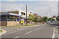
Shops on Sandy Lane
These shops, probably built in the 1960s, are, in my view, badly laid out. They face directly onto the street with pointless hard landscaping in front of them but little parking. There is parking behind the shops, but you are then faced with a long walk. Eastleigh Borough Council recently remodelled the road and put the yellow bollards in. That made it easier to cross the road but reduced the parking. The shops are L-shaped and for view to the left see Image
Image: © Peter Facey
Taken: 23 Jul 2008
0.08 miles
3
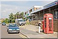
Telephone Box and Shops in Latham Road
Another telephone box with a notice threatening removal within 42 days. There is no glass in the lower half of the door. The shops, probably built in the 1960s, are, in my view, badly laid out. They face directly onto the street with pointless hard landscaping in front of them but little parking. There is parking behind the shops, but you are then faced with a long walk.
Image: © Peter Facey
Taken: 23 Jul 2008
0.10 miles

6
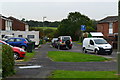
For whom will it be beastly in Eastleigh? (2)
This 2013 by-election http://en.wikipedia.org/wiki/Eastleigh_by-election,_2013 was called when its MP http://en.wikipedia.org/wiki/Chris_Huhne resigned in unfortunate circumstances.
Coming at a time when the Coalition http://en.wikipedia.org/wiki/Conservative_%E2%80%93_Liberal_Democrat_coalition_agreement was struggling for credibility, it attracted huge interest from the national media and resulted in a diverse range of political activists flocking to the constituency.
This is a polling station in Shorts Road, Bishopstoke.
Image: © Basher Eyre
Taken: 28 Feb 2013
0.16 miles
9
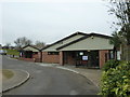
Public Library, Fair Oak: mid March 2013
Image: © Basher Eyre
Taken: 13 Mar 2014
0.18 miles
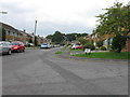
10
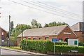
The Gospel Hall, Sandy Lane, Fairoak
"An assembly of Christian brethren". On the corner of Shorts Road and Sandy Lane.
Image: © Peter Facey
Taken: 23 Jul 2008
0.19 miles