IMAGES TAKEN NEAR TO
Durley Road, EASTLEIGH, SO50 7DY
Introduction
This page details the photographs taken nearby to Durley Road, SO50 7DY by members of the Geograph project.
The Geograph project started in 2005 with the aim of publishing, organising and preserving representative images for every square kilometre of Great Britain, Ireland and the Isle of Man.

There are currently over 7.5m images from over14,400 individuals and you can help contribute to the project by visiting https://www.geograph.org.uk
Image Map
Images are licensed for reuse under creativecommons.org/licenses/by-sa/2.0
Notes
- Clicking on the map will re-center to the selected point.
- The higher the marker number, the further away the image location is from the centre of the postcode.
Image Listing (8 Images Found)
Images are licensed for reuse under creativecommons.org/licenses/by-sa/2.0
Image
Details
Distance
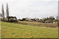
2
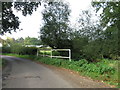
Holme Farm, Horton Heath
Seen from footpath at corner of recently-built Huntingdon Gardens.
Image: © Peter Facey
Taken: 30 Mar 2008
0.11 miles
3
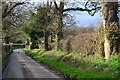
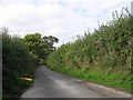
Late afternoon sunshine in Durley Road
Image: © David Martin
Taken: 18 Mar 2017
0.12 miles
4
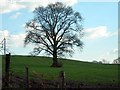
The Lonely Tree
This Lonely Tree is in a Field just off Durley Road. Horton Heath is to the west & Durley village to the south-east. The Photo is looking towards the south.
Image: © Jim Goldsmith
Taken: 5 Apr 2006
0.18 miles
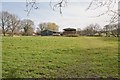
6
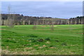
View across East Horton Golf Course from Durley Road
Image: © David Martin
Taken: 18 Mar 2017
0.22 miles
7
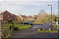
Part of Huntingdon Gardens, Horton Heath
Built in last five years on former fields.
Image: © Peter Facey
Taken: 30 Mar 2008
0.23 miles
8
Looking across field towards Knowle Lane
From footpath.
Image: © Peter Facey
Taken: 30 Mar 2008
0.25 miles