IMAGES TAKEN NEAR TO
Bradshaw Close, EASTLEIGH, SO50 7BS
Introduction
This page details the photographs taken nearby to Bradshaw Close, SO50 7BS by members of the Geograph project.
The Geograph project started in 2005 with the aim of publishing, organising and preserving representative images for every square kilometre of Great Britain, Ireland and the Isle of Man.

There are currently over 7.5m images from over14,400 individuals and you can help contribute to the project by visiting https://www.geograph.org.uk
Image Map
Images are licensed for reuse under creativecommons.org/licenses/by-sa/2.0
Notes
- Clicking on the map will re-center to the selected point.
- The higher the marker number, the further away the image location is from the centre of the postcode.
Image Listing (24 Images Found)
Images are licensed for reuse under creativecommons.org/licenses/by-sa/2.0
Image
Details
Distance
1
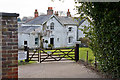
Number 79, Mortimers Lane, Fair Oak
In spite of its banal name, it appears this is one of the older properties in the lane.
Image: © Peter Facey
Taken: 28 Feb 2009
0.04 miles
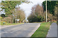
2
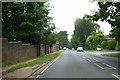
B3037 Mortimers Lane
Heading into Fairoak.
Image: © Robin Webster
Taken: 10 Jun 2018
0.06 miles
3
Mortimers Lane, Fair Oak
Approaching Camelia Grove (on right).
Image: © Peter Facey
Taken: 28 Feb 2009
0.07 miles
4
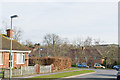
Mimosa Drive, Fair Oak
Seen looking across Mortimer Lane (the B3037). The turning on left (to right of the lamp post) is Cedar Wood Close.
Image: © Peter Facey
Taken: 28 Feb 2009
0.08 miles
5
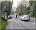
Knowle Lane joins Mortimers Lane
Knowle Lane is the turning on the right. It is frequently used due to there being a Hampshire County Council household waste recycling centre there.
Image: © Peter Facey
Taken: 28 Feb 2009
0.11 miles
6
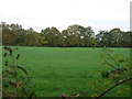
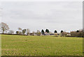
Yet another horse field
Lots of horsiculture round here
Image: © Hugh Venables
Taken: 12 Nov 2005
0.11 miles
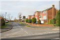
8
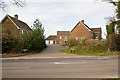
Hightrees, Mortimer Lane
A residential close.
Image: © Peter Facey
Taken: 28 Feb 2009
0.12 miles
9
Scotland Close, off Mortimer Lane
Some distance beyond you can see the tops of buildings in Deer Park Farm Industrial Estate.
Image: © Peter Facey
Taken: 28 Feb 2009
0.13 miles
10
View towards Pembers Hill Farm
View across fields to Pembers Hill Farm from Hall Lands Lane. The house on the left end of the barn must be of recent construction; it is not shown on maps or aerial views.
Image: © Peter Facey
Taken: 28 Feb 2009
0.14 miles