IMAGES TAKEN NEAR TO
Fair Oak Road, EASTLEIGH, SO50 7AB
Introduction
This page details the photographs taken nearby to Fair Oak Road, SO50 7AB by members of the Geograph project.
The Geograph project started in 2005 with the aim of publishing, organising and preserving representative images for every square kilometre of Great Britain, Ireland and the Isle of Man.

There are currently over 7.5m images from over14,400 individuals and you can help contribute to the project by visiting https://www.geograph.org.uk
Image Map
Images are licensed for reuse under creativecommons.org/licenses/by-sa/2.0
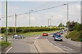
Notes
- Clicking on the map will re-center to the selected point.
- The higher the marker number, the further away the image location is from the centre of the postcode.
Image Listing (44 Images Found)
Images are licensed for reuse under creativecommons.org/licenses/by-sa/2.0
Image
Details
Distance
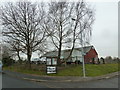
1
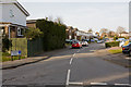
Junction of Allington Lane and Fairoak Road
Allington Lane is at left. It's a long semi-rural lane but with houses and businesses dotted along it.
Image: © Peter Facey
Taken: 23 Jul 2008
0.06 miles
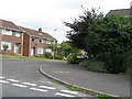
2
The northern end of Allington Lane
Seen from its junction with Fairoak Road.
Image: © Peter Facey
Taken: 23 Jul 2008
0.07 miles
4
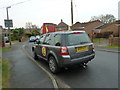
For whom will it be beastly in Eastleigh? (3)
The vehicle from which Diane James http://thebackbencher.co.uk/why-im-standing-diane-james-ukip/UKIP candidate at today's by-election has just got into.
Image: © Basher Eyre
Taken: 28 Feb 2013
0.09 miles
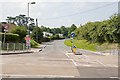
5
For whom will it be beastly in Eastleigh? (1)
This 2013 by-election http://en.wikipedia.org/wiki/Eastleigh_by-election,_2013 was called when its MP http://en.wikipedia.org/wiki/Chris_Huhne resigned in unfortunate circumstances.
Coming at a time when the Coalition http://en.wikipedia.org/wiki/Conservative_%E2%80%93_Liberal_Democrat_coalition_agreement was struggling for credibility, it attracted huge interest from the national media and resulted in a diverse range of political activists flocking to the constituency.
This is the entrance to a polling station in Shorts Road, Bishopstoke.
Image: © Basher Eyre
Taken: 28 Feb 2013
0.09 miles
7
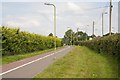
Cycle Path going from Allington Lane to Blackberry Drive
This runs parallel to Fairoak Road which is over the hedge at right.
Image: © Peter Facey
Taken: 23 Jul 2008
0.10 miles
8
Traffic Lights on Fairoak Road at Sandy Lane
Image: © Peter Facey
Taken: 23 Jul 2008
0.11 miles
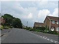
9
Trafford Road
Marked on street maps as Trafford Way.
Image: © Peter Facey
Taken: 16 Mar 2010
0.11 miles
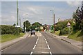
10
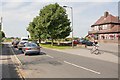
Sandy Lane approaches traffic lights at Fairoak Road
With the New Clock Inn on the right.
Image: © Peter Facey
Taken: 23 Jul 2008
0.11 miles