IMAGES TAKEN NEAR TO
Oakgrove Road, EASTLEIGH, SO50 6LL
Introduction
This page details the photographs taken nearby to Oakgrove Road, SO50 6LL by members of the Geograph project.
The Geograph project started in 2005 with the aim of publishing, organising and preserving representative images for every square kilometre of Great Britain, Ireland and the Isle of Man.

There are currently over 7.5m images from over14,400 individuals and you can help contribute to the project by visiting https://www.geograph.org.uk
Image Map
Images are licensed for reuse under creativecommons.org/licenses/by-sa/2.0
Notes
- Clicking on the map will re-center to the selected point.
- The higher the marker number, the further away the image location is from the centre of the postcode.
Image Listing (27 Images Found)
Images are licensed for reuse under creativecommons.org/licenses/by-sa/2.0
Image
Details
Distance
1
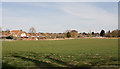
Field and the backs of houses in Oakgrove Road
Seen from footpath.
Image: © Peter Facey
Taken: 16 Mar 2010
0.06 miles
2
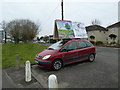
For whom will it be beastly in Eastleigh? (7)
This 2013 by-election http://en.wikipedia.org/wiki/Eastleigh_by-election,_2013 was called when its MP http://en.wikipedia.org/wiki/Chris_Huhne resigned in unfortunate circumstances.
Coming at a time when the Coalition http://en.wikipedia.org/wiki/Conservative_%E2%80%93_Liberal_Democrat_coalition_agreement was struggling for credibility, it attracted huge interest from the national media and resulted in a diverse range of political activists flocking to the constituency.
Seen in Alan Drayton Way, Bishopstoke this is a vehicular advert for an independent http://site.prayer-alert.net/index.php?option=com_content&view=article&id=2864:christian-to-stand-in-eastleigh-by-election&catid=40:british-isles-a-ireland&Itemid=94
Image: © Basher Eyre
Taken: 28 Feb 2013
0.09 miles
3
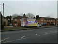
For whom will it be beastly in Eastleigh? (6)
This 2013 by-election http://en.wikipedia.org/wiki/Eastleigh_by-election,_2013 was called when its MP http://en.wikipedia.org/wiki/Chris_Huhne resigned in unfortunate circumstances.
Coming at a time when the Coalition http://en.wikipedia.org/wiki/Conservative_%E2%80%93_Liberal_Democrat_coalition_agreement was struggling for credibility, it attracted huge interest from the national media and resulted in a diverse range of political activists flocking to the constituency.
This is a UKIP poster van at Bishopstoke.
Image: © Basher Eyre
Taken: 28 Feb 2013
0.09 miles
4
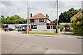
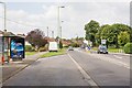
Businesses on corner of Fairoak Road and Alan Drayton Way
The shop on the right, B & K Pet Supplies, is no more. Locals tell me that before that it was a cycle shop. On the left is DG Supplies which sells sand and ballast in the old fashioned way out of open bays: take your trailer along and load as much as you require.
Image: © Peter Facey
Taken: 23 Jul 2008
0.09 miles
5
Fairoak Road, west on Manor Road
At this point Alan Drayton Way turns back into Fairoak Road. The Way is a modern road that bypasses a large residential curve of Fairoak Road. For its other end see Image
Image: © Peter Facey
Taken: 23 Jul 2008
0.10 miles
6
Field and the backs of houses in Oakgrove Gardens
Strictly speaking the public footpath runs diagonally across this field from the trees at left. However, I followed others in walking around the edge of the field, there being no obvious path across the crop.
Image: © Peter Facey
Taken: 16 Mar 2010
0.12 miles
7
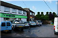
Shops on Fairoak Road
West of Manor Road. The Co op and Shock Cuts hair studio.
Image: © Peter Facey
Taken: 23 Jul 2008
0.15 miles
8
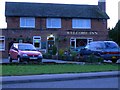
The Welcome Inn
Located in Bishopstoke,(between Eastleigh & Fair Oak). It is a good example of an estate pub. They currently have two teams in the Bishop's Waltham Pool League.
Image: © Jim Goldsmith
Taken: 21 Jan 2006
0.16 miles
9
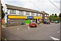
The Co-op, Bishopstoke, Hampshire
As I walked past, the nearby topiary caught my eye.
Image: © Peter Trimming
Taken: 17 Oct 2012
0.17 miles
10
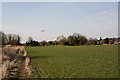
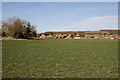
Field south of Bishopstoke
Bounded on its left side by a drainage ditch. The plane is on the runway alignment for landing at Southampton Airport.
Image: © Peter Facey
Taken: 16 Mar 2010
0.17 miles