IMAGES TAKEN NEAR TO
Gilbert Avenue, EASTLEIGH, SO50 6JG
Introduction
This page details the photographs taken nearby to Gilbert Avenue, SO50 6JG by members of the Geograph project.
The Geograph project started in 2005 with the aim of publishing, organising and preserving representative images for every square kilometre of Great Britain, Ireland and the Isle of Man.

There are currently over 7.5m images from over14,400 individuals and you can help contribute to the project by visiting https://www.geograph.org.uk
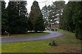
Image Map
Images are licensed for reuse under creativecommons.org/licenses/by-sa/2.0
Notes
- Clicking on the map will re-center to the selected point.
- The higher the marker number, the further away the image location is from the centre of the postcode.
Image Listing (34 Images Found)
Images are licensed for reuse under creativecommons.org/licenses/by-sa/2.0
Image
Details
Distance
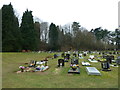
1
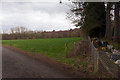
Field northeast of Bishopstoke Cemetery
This field would have houses built upon it, should the proposed development gain planning permission.
Image: © Peter Facey
Taken: 4 Mar 2014
0.01 miles
2
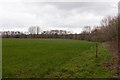
Field northeast of Bishopstoke Cemetery
This field would have houses built upon it, should the proposed development gain planning permission. The photo only shows the eastern side of this field.
Image: © Peter Facey
Taken: 4 Mar 2014
0.03 miles
3
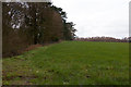
Field northeast of Bishopstoke Cemetery
This field would have houses built upon it, should the proposed development gain planning permission. The photo only shows the part of the field that adjoins the cemetery.
Image: © Peter Facey
Taken: 4 Mar 2014
0.03 miles
4
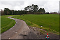
Field north of Bishopstoke Cemetery
The cemetery is in the fir trees ahead. Fields on both sides of this access road to Stoke Park Farm would have houses built upon them, should the proposed development go ahead.
[elevated camera position]
Image: © Peter Facey
Taken: 4 Mar 2014
0.05 miles
6
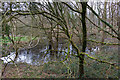
Pond at eastern corner of Bishopstoke Cemetery
This pond may not be there all the time, but certainly was after the wettest winter for many years.
Image: © Peter Facey
Taken: 4 Mar 2014
0.06 miles
7
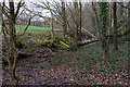
Field/woodland boundary northeast of Bishopstoke cemetery
A bank here has scattered moss-covered lumps of concrete.
Image: © Peter Facey
Taken: 4 Mar 2014
0.06 miles
8
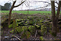
Field/woodland boundary northeast of Bishopstoke cemetery
Showing moss-covered concrete boulders on the bank at the edge of the field.
Image: © Peter Facey
Taken: 4 Mar 2014
0.06 miles
10
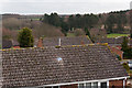
View of development site from Burrow Hill
In fact, the proposed development site is not easy to see. This is the view from Burrow Hill, the highest nearby point, with me standing upon Image, and holding the camera above my head on a monopod. The existing cemetery is in the fir trees at the centre of the picture. The brown field to the right would be the cemetery extension. The lower of the two strips of green at left of the picture would have houses built on it. The green field at right would become open space, and the field at centre (below the fir trees) would become allotments.
Image: © Peter Facey
Taken: 4 Mar 2014
0.07 miles