IMAGES TAKEN NEAR TO
Oakbank Road, EASTLEIGH, SO50 6HF
Introduction
This page details the photographs taken nearby to Oakbank Road, SO50 6HF by members of the Geograph project.
The Geograph project started in 2005 with the aim of publishing, organising and preserving representative images for every square kilometre of Great Britain, Ireland and the Isle of Man.

There are currently over 7.5m images from over14,400 individuals and you can help contribute to the project by visiting https://www.geograph.org.uk
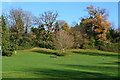
Image Map
Images are licensed for reuse under creativecommons.org/licenses/by-sa/2.0
Notes
- Clicking on the map will re-center to the selected point.
- The higher the marker number, the further away the image location is from the centre of the postcode.
Image Listing (102 Images Found)
Images are licensed for reuse under creativecommons.org/licenses/by-sa/2.0
Image
Details
Distance
1
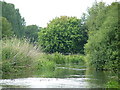
The Itchen Navigation Canal, Bishopstoke
Where the Navigation canal joins the main River Itchen
Image: © Chris Hayles
Taken: 11 Jul 2004
0.03 miles
4
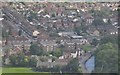
Eastleigh District : Bishopstoke Scenery
From a flight heading into Southampton looking down to Bishopstoke.
Image: © Lewis Clarke
Taken: 28 Aug 2012
0.03 miles
5
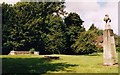
Remains of Old Church, Bishopstoke
Built in the 14th century and demolished in 1965.
Image: © Michael FORD
Taken: Unknown
0.04 miles
6
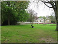
Open area south of Oakbank Road, Bishopstoke.
Image: © Alex McGregor
Taken: 3 May 2012
0.04 miles
7
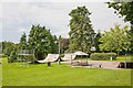
Skate Board Park within Glebe Meadow Recreation Ground, Bishopstoke
Image: © Peter Facey
Taken: 23 Jul 2008
0.04 miles
8

Garden in Glebe Meadow Recreation Ground, Bishopstoke
Image: © Peter Facey
Taken: 23 Jul 2008
0.05 miles