IMAGES TAKEN NEAR TO
Sayers Road, EASTLEIGH, SO50 6GW
Introduction
This page details the photographs taken nearby to Sayers Road, SO50 6GW by members of the Geograph project.
The Geograph project started in 2005 with the aim of publishing, organising and preserving representative images for every square kilometre of Great Britain, Ireland and the Isle of Man.

There are currently over 7.5m images from over14,400 individuals and you can help contribute to the project by visiting https://www.geograph.org.uk
Image Map
Images are licensed for reuse under creativecommons.org/licenses/by-sa/2.0
Notes
- Clicking on the map will re-center to the selected point.
- The higher the marker number, the further away the image location is from the centre of the postcode.
Image Listing (45 Images Found)
Images are licensed for reuse under creativecommons.org/licenses/by-sa/2.0
Image
Details
Distance

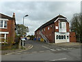
2
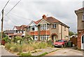
Dilapidated house in Fairoak Road, east of Sayers Road
The left half of this semi-detached house is well kept up; the right much less so.
Image: © Peter Facey
Taken: 23 Jul 2008
0.10 miles
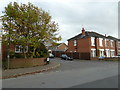
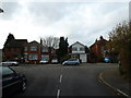
3

Houses overlooking mini roundabout in Underwood Road
Image: © David Martin
Taken: 30 Nov 2018
0.12 miles
4
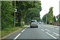
B3037 Fairoak Road
Heading towards Eastleigh.
Image: © Robin Webster
Taken: 10 Jun 2018
0.13 miles
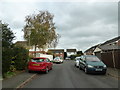
5

New houses under construction at Bishopstoke
Complete with standard issue garden sheds.
Image: © David Martin
Taken: 30 Nov 2018
0.13 miles
6

New houses under construction at Bishopstoke
Image: © David Martin
Taken: 30 Nov 2018
0.13 miles
7
Approaching the junction of Scotter Road and Scotter Square
Image: © Basher Eyre
Taken: 26 Nov 2011
0.15 miles
10
Looking from Scotter Square into Scotter Road
Image: © Basher Eyre
Taken: 26 Nov 2011
0.16 miles