IMAGES TAKEN NEAR TO
St. Margarets Road, EASTLEIGH, SO50 6DH
Introduction
This page details the photographs taken nearby to St. Margarets Road, SO50 6DH by members of the Geograph project.
The Geograph project started in 2005 with the aim of publishing, organising and preserving representative images for every square kilometre of Great Britain, Ireland and the Isle of Man.

There are currently over 7.5m images from over14,400 individuals and you can help contribute to the project by visiting https://www.geograph.org.uk
Image Map
Images are licensed for reuse under creativecommons.org/licenses/by-sa/2.0
Notes
- Clicking on the map will re-center to the selected point.
- The higher the marker number, the further away the image location is from the centre of the postcode.
Image Listing (65 Images Found)
Images are licensed for reuse under creativecommons.org/licenses/by-sa/2.0
Image
Details
Distance
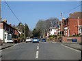
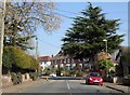
2
Junction between Stoke Park Road and Church Road
Church Road (left to right), Stoke Park Road (behind), St Margaret's Road (ahead).
Image: © Peter Facey
Taken: 23 Jul 2008
0.09 miles
3
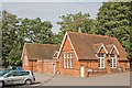
Bishopstoke Community Centre, Church Road
The only remaining building of the old Bishopstoke Infant School; built over a hundred years ago so was protected from development of the site back in the 1990's. The infant school site used to cover the whole of what is now Sydney Road and the Community Centre/grounds, with the exception of the oldest houses in Sydney road as you first enter the road (two on the left and four on the right) up to and including the house with the large magnolia tree out front on the right. The third house on the left as you enter Sydney Road was part of the new development which leads a cul de sac to the left, and sits on the site where there was an assembly hall, kitchens, and further down the hill there was a small school swimming pool, with playing fields opposite.
Image: © Peter Facey
Taken: 15 Sep 2008
0.10 miles
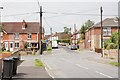
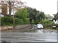
4
Junction between Church Road and Spring Lane
The northern end of Spring Lane is the road on the left. Ashford Grove on the right.
Image: © Peter Facey
Taken: 23 Jul 2008
0.11 miles
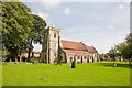
8
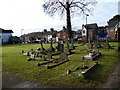
St Mary's Church, Bishopstoke: churchyard
Image: © Basher Eyre
Taken: 2 Jan 2011
0.14 miles
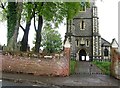
9
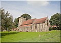
St Mary's Church, Bishopstoke
See http://www.bishopstoke.org/
Image: © Peter Facey
Taken: 15 Sep 2008
0.14 miles
10
St Mary's Church, Bishopstoke
See http://www.bishopstoke.org/
Image: © Peter Facey
Taken: 15 Sep 2008
0.14 miles