IMAGES TAKEN NEAR TO
Swan Green, LYNDHURST, SO43 7DT
Introduction
This page details the photographs taken nearby to Swan Green, SO43 7DT by members of the Geograph project.
The Geograph project started in 2005 with the aim of publishing, organising and preserving representative images for every square kilometre of Great Britain, Ireland and the Isle of Man.

There are currently over 7.5m images from over14,400 individuals and you can help contribute to the project by visiting https://www.geograph.org.uk
Image Map
Images are licensed for reuse under creativecommons.org/licenses/by-sa/2.0
Notes
- Clicking on the map will re-center to the selected point.
- The higher the marker number, the further away the image location is from the centre of the postcode.
Image Listing (17 Images Found)
Images are licensed for reuse under creativecommons.org/licenses/by-sa/2.0
Image
Details
Distance
1
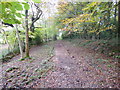
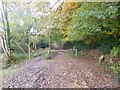
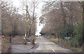
Emery Down, byway
From Silver Street to Bunker's Hill; at this point, restricted byway, later, bridleway.
Image: © Mike Faherty
Taken: 12 Nov 2013
0.12 miles
2
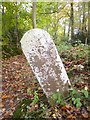
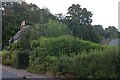
Old Boundary Marker by Silver Street path, Emery Down, Minstead Parish
Estate Boundary Marker by the footpath, in parish of Minstead (New Forest District), Emery Down, continuation of Silver Street, at field entrance.
Surveyed
Milestone Society National ID: HA_MINM01em
Image: © Milestone Society
Taken: Unknown
0.12 miles
3
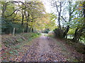
Emery Down, byway
From Bunker's Hill to Silver Street; first, bridleway, here, restricted byway.
Image: © Mike Faherty
Taken: 12 Nov 2013
0.13 miles
4
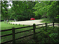
Emery Down, sheep grazing
Horned sheep in a field next to the bridleway to Bunker's Hill.
Image: © Mike Faherty
Taken: 12 Nov 2013
0.15 miles
5
Emery Down, gateway
On the bridleway from Silver Street to Bunker's Hill.
Image: © Mike Faherty
Taken: 12 Nov 2013
0.16 miles
8
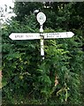
Old Direction Sign - Signpost near Fox's Hill, Minstead parish
Disc finial with New Forest ponies and tree - 2 arms; by the UC road, in parish of Minstead (New Forest District), junction near Fox's Hill, Minstead, in the hedge.
To be surveyed
Milestone Society National ID: HA_SU2808C
Image: © Milestone Society
Taken: Unknown
0.24 miles
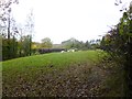
10
Swan Green car park
New Forest car park between Lyndhurst and Emery Down.
Image: © Hugh Venables
Taken: 27 May 2016
0.24 miles