IMAGES TAKEN NEAR TO
Grosvenor Mews, LYMINGTON, SO41 9JY
Introduction
This page details the photographs taken nearby to Grosvenor Mews, SO41 9JY by members of the Geograph project.
The Geograph project started in 2005 with the aim of publishing, organising and preserving representative images for every square kilometre of Great Britain, Ireland and the Isle of Man.

There are currently over 7.5m images from over14,400 individuals and you can help contribute to the project by visiting https://www.geograph.org.uk
Image Map
Images are licensed for reuse under creativecommons.org/licenses/by-sa/2.0
Notes
- Clicking on the map will re-center to the selected point.
- The higher the marker number, the further away the image location is from the centre of the postcode.
Image Listing (18 Images Found)
Images are licensed for reuse under creativecommons.org/licenses/by-sa/2.0
Image
Details
Distance
1
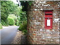
Lymington: postbox № SO41 39, Hollywood Lane
Looking along Hollywood Lane from its western end, past this Elizabeth II-reign postbox which, though of a design more often found mounted on a metal pole, is set into a brick wall. The box is emptied finally at 5:15pm on weekdays and at 11:45am on Saturdays.
Image: © Chris Downer
Taken: 11 Jun 2011
0.04 miles
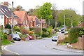
2
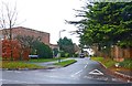
Paddock Gardens, Buckland
Beyond the flat-roofed town houses, there is a substantial new development of traditional housing.
Image: © mike smith
Taken: 17 Dec 2013
0.06 miles
3

Hollywood Lane, Buckland
New housing developments are appearing in the area, but this lane seems to be untouched by time. It has a number of very large houses along its length. No doubt it is named after a copse of holly trees, and not after the suburb of Los Angeles!
Image: © mike smith
Taken: 17 Dec 2013
0.07 miles
4
Stratford Place, Buckland
This is a pleasant development of luxury bungalows to the north of Lymington.
Image: © mike smith
Taken: 17 Dec 2013
0.12 miles
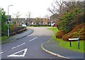
5
Lower Buckland Road, Lower Buckland, Hampshire
A quiet back street, on the outskirts of Lymington.
Image: © Peter Trimming
Taken: 8 Apr 2010
0.16 miles
6
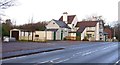
Empty Tollhouse Inn at Buckland
This pub and restaurant has been empty since the landlord and his wife set fire to it causing considerable internal damage. They were jailed in January 2013. See more information here: http://www.bournemouthecho.co.uk/news/10142586.Lymington_landlord_and_his_wife_are_jailed_for_torching_their_own_pub/
Image: © mike smith
Taken: 17 Dec 2013
0.18 miles
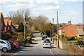
7
Lower Buckland Road
This road is a useful cut-through from the north of Lymington towards the New Forest Hospital and beyond to Brockenhurst.
Image: © mike smith
Taken: 19 Apr 2014
0.18 miles
8
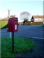
Lymington: postbox № SO41 140, May Avenue
This postbox stands close to the staggered crossroads with Lower Buckland Road - Lower Buckland Post Office was somewhere hereabouts until its closure on 14 May 2003. I expect the box was repositioned here from outside the post office at around that time.
Image: © Chris Downer
Taken: 11 Jan 2014
0.18 miles
9
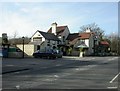
Buckland, Tollhouse Inn
Pub on Southampton Road; internally, straight bar, with drinking to left & eating to right; wooden beams, open fire & darts. Cask ales on offer at my visit: Ringwood Best, Fortyniner, Sharp's Doom Bar. For some customer comments, see http://www.beerintheevening.com/pubs/s/37/3732/Tollhouse_Inn/Lymington If this pub was originally a tollhouse, it would have been the first northwards on the Lymington, Lyndhurst & Rumbridge Turnpike Trust.
Image: © Mike Faherty
Taken: 4 Mar 2010
0.18 miles
10
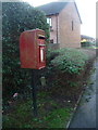
Lymington: postbox № SO41 20, Alexandra Road
This postbox serves a modern housing estate on the northern fringe of the town. It is an Elizabeth II-reign box and we can tell that it dates from no earlier than 1994 because it has the words ROYAL MAIL rather than POST OFFICE above the slot.
Image: © Chris Downer
Taken: 11 Jan 2014
0.18 miles