IMAGES TAKEN NEAR TO
Fullerton Road, LYMINGTON, SO41 9JP
Introduction
This page details the photographs taken nearby to Fullerton Road, SO41 9JP by members of the Geograph project.
The Geograph project started in 2005 with the aim of publishing, organising and preserving representative images for every square kilometre of Great Britain, Ireland and the Isle of Man.

There are currently over 7.5m images from over14,400 individuals and you can help contribute to the project by visiting https://www.geograph.org.uk
Image Map
Images are licensed for reuse under creativecommons.org/licenses/by-sa/2.0
Notes
- Clicking on the map will re-center to the selected point.
- The higher the marker number, the further away the image location is from the centre of the postcode.
Image Listing (11 Images Found)
Images are licensed for reuse under creativecommons.org/licenses/by-sa/2.0
Image
Details
Distance
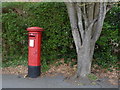
1
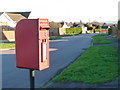
Lymington: postbox № SO41 188, Highfield Road
Looking down Highfield Road as this Elizabeth II-reign postbox catches some winter sunlight from between two bungalows.
Image: © Chris Downer
Taken: 11 Jan 2014
0.12 miles
2
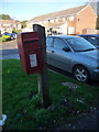
Lymington: postbox № SO41 78, Pamplyn Close
An Elizabeth II-reign postbox strapped to a wooden post in a shady spot at this time of year.
Image: © Chris Downer
Taken: 11 Jan 2014
0.13 miles
3
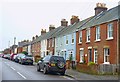
Western Road, Lymington
This road has several terraced Victorian/Edwardian houses along its length.
Image: © mike smith
Taken: 14 Dec 2013
0.15 miles
4
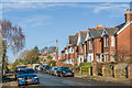
Southern Road
Mainly early 20th Century houses in Southern Road, with the nearer two first marked on the 1908 25 inch map.
Image: © Ian Capper
Taken: 19 Jan 2023
0.15 miles
5
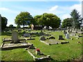
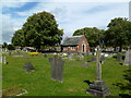
Lymington Cemetery
On Highfield Road; maintained by New Forest District Council.
Image: © Mike Faherty
Taken: 4 Sep 2011
0.16 miles
8
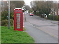
Lymington: phone box in Highfield Road
A red phone box on this suburban street.
Image: © Chris Downer
Taken: 20 Mar 2014
0.20 miles
9
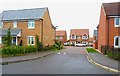
Houses on former Hospital Site
The original Lymington Hospital moved about one kilometre to the north in 2007.
The old buildings were demolished and a housing estate was built on the land.
Image: © mike smith
Taken: 14 Dec 2013
0.22 miles
10
Lymington: postbox № SO41 169, Highfield Road
A George VI-reign postbox almost at the eastern end of Highfield Road, as it comes out on Southern Road.
Image: © Chris Downer
Taken: 20 Mar 2014
0.22 miles