IMAGES TAKEN NEAR TO
Rope Hill, LYMINGTON, SO41 8QW
Introduction
This page details the photographs taken nearby to Rope Hill, SO41 8QW by members of the Geograph project.
The Geograph project started in 2005 with the aim of publishing, organising and preserving representative images for every square kilometre of Great Britain, Ireland and the Isle of Man.

There are currently over 7.5m images from over14,400 individuals and you can help contribute to the project by visiting https://www.geograph.org.uk
Image Map
Images are licensed for reuse under creativecommons.org/licenses/by-sa/2.0
Notes
- Clicking on the map will re-center to the selected point.
- The higher the marker number, the further away the image location is from the centre of the postcode.
Image Listing (40 Images Found)
Images are licensed for reuse under creativecommons.org/licenses/by-sa/2.0
Image
Details
Distance
1
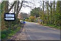
Entering Boldre from the East
This is one of four entrances to the small village. Note the old-fashioned direction sign with all destinations shown in capital letters rather than the current mixed case signs.
Image: © mike smith
Taken: 12 Mar 2014
0.01 miles
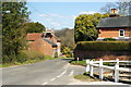
2
House on Rope Hill, Boldre, Hampshire
Looking in this direction, Rope Hill drops down to Boldre Bridge, over the River Lymington.
Image: © Peter Trimming
Taken: 8 Apr 2010
0.02 miles
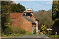
3

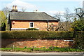
Large House at Boldre
This dwelling would appear to be a new build, albeit in traditional style.
Image: © mike smith
Taken: 12 Mar 2014
0.02 miles
4
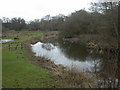
Boldre, Lymington River
Looking North (upstream) from Image
Image: © Mike Faherty
Taken: 12 Feb 2010
0.03 miles
5
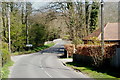
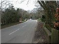
Towards Boldre Bridge, Hampshire
Looking down the hill, towards the bridge, which crosses the River Lymington. The village sign says "Boldre" on both sides.
Image: © Peter Trimming
Taken: 8 Apr 2010
0.03 miles
6
House at Boldre, Hampshire
Located at the end of Boldre Lane.
Image: © Peter Trimming
Taken: 8 Apr 2010
0.03 miles
7
Boldre, old post office
At the northern end of Boldre Lane. Note the postbox (with GVR cypher) on the chimney stack, albeit painted black and blocked off.
Image: © Mike Faherty
Taken: 14 Feb 2010
0.03 miles
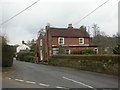
8
Rope Hill, Boldre, Hampshire
Seen from the Red Lion; the junction of Rope Hill, and Boldre Lane.
Image: © Peter Trimming
Taken: 8 Apr 2010
0.03 miles
9
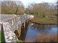
Boldre Bridge
Five-arched stone bridge over Lymington River; listed by English Heritage. http://www.imagesofengland.org.uk/Details/Default.aspx?id=144273&mode=adv
Image: © Mike Faherty
Taken: 12 Feb 2010
0.04 miles
10
Boldre Bridge
This is a Grade II listed structure. It dates from the late 18th century and is made of Ashlar stone.
Image: © mike smith
Taken: 12 Mar 2014
0.04 miles