IMAGES TAKEN NEAR TO
Ricardo Way, LYMINGTON, SO41 8JU
Introduction
This page details the photographs taken nearby to Ricardo Way, SO41 8JU by members of the Geograph project.
The Geograph project started in 2005 with the aim of publishing, organising and preserving representative images for every square kilometre of Great Britain, Ireland and the Isle of Man.

There are currently over 7.5m images from over14,400 individuals and you can help contribute to the project by visiting https://www.geograph.org.uk
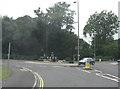
Image Map
Images are licensed for reuse under creativecommons.org/licenses/by-sa/2.0
Notes
- Clicking on the map will re-center to the selected point.
- The higher the marker number, the further away the image location is from the centre of the postcode.
Image Listing (37 Images Found)
Images are licensed for reuse under creativecommons.org/licenses/by-sa/2.0
Image
Details
Distance
1
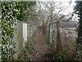
Buckland, footpath
Footpath from Lower Buckland to Boldre Lane. To the left, gardens in Boldre Lane, to the right, vacant land on the old factory site.
Image: © Mike Faherty
Taken: 19 Feb 2010
0.07 miles
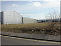
2
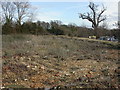
Buckland, waste ground
At the junction of Ampress Lane & Ricardo Way, on the former Wellworthy Works site. No doubt a new unit will spring up here soon.
Image: © Mike Faherty
Taken: 4 Mar 2010
0.07 miles
3
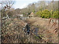
Buckland, Passford Water
A stream rising to the North-west and joining Lymington River 500m to the East of here. As seen looking upstream towards Southampton Road (A337).
Image: © Mike Faherty
Taken: 19 Feb 2010
0.09 miles
4
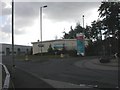
Buckland, supermarket
Somerfield, supermarket with filling station (out of sight), on Wellworthy Road.
Image: © Mike Faherty
Taken: 19 Feb 2010
0.09 miles
5
Buckland, Ampress Park
Newly completed buildings on the business park, off Ampress Lane; a plot still to be filled to the front.
Image: © Mike Faherty
Taken: 4 Mar 2010
0.09 miles
6
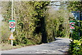
Boldre Lane, Buckland, Hampshire
At the junction with the A337, looking towards Boldre.
Image: © Peter Trimming
Taken: 8 Apr 2010
0.11 miles
7
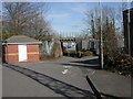
Buckland, railway bridge
Bridge on the Lymington branch line over the footpath from Southampton Road to Wellworthy Road; new business units visible on the other side of the bridge.
Image: © Mike Faherty
Taken: 4 Mar 2010
0.11 miles
8
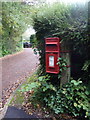
Lymington: postbox № SO41 130, Boldre Lane
A small postbox serving the smattering of properties on the lane to Boldre, as its name suggests.
Image: © Chris Downer
Taken: 26 Oct 2013
0.11 miles
9

New Forest Ice Cream Factory
This brand of ice cream is highly regarded, and is sold in many outlets in south-west Hampshire and Dorset.
Image: © mike smith
Taken: 19 Apr 2014
0.11 miles
10
A337 junction with Wellworthy Road
Wellworthy Road now leads to Lymington New Forest Hospital. Previously the site was occupied by the factory of Wellworthy Piston Rings Limited.
Image: © Stuart Logan
Taken: 4 Aug 2011
0.11 miles