IMAGES TAKEN NEAR TO
Bays Road, LYMINGTON, SO41 8HN
Introduction
This page details the photographs taken nearby to Bays Road, SO41 8HN by members of the Geograph project.
The Geograph project started in 2005 with the aim of publishing, organising and preserving representative images for every square kilometre of Great Britain, Ireland and the Isle of Man.

There are currently over 7.5m images from over14,400 individuals and you can help contribute to the project by visiting https://www.geograph.org.uk
Image Map
Images are licensed for reuse under creativecommons.org/licenses/by-sa/2.0
Notes
- Clicking on the map will re-center to the selected point.
- The higher the marker number, the further away the image location is from the centre of the postcode.
Image Listing (13 Images Found)
Images are licensed for reuse under creativecommons.org/licenses/by-sa/2.0
Image
Details
Distance
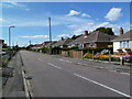
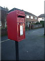
4
Lymington: postbox № SO41 188, Highfield Road
Looking down Highfield Road as this Elizabeth II-reign postbox catches some winter sunlight from between two bungalows.
Image: © Chris Downer
Taken: 11 Jan 2014
0.10 miles
5
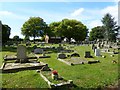
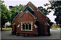
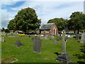
Lymington Cemetery
On Highfield Road; maintained by New Forest District Council.
Image: © Mike Faherty
Taken: 4 Sep 2011
0.11 miles
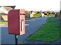
6
Lymington: postbox № SO41 204, Gordon Road
A standard Elizabeth II-reign (pre-1994) postbox on a metal pole, opposite the Bays Road turning.
Image: © Chris Downer
Taken: 11 Jan 2014
0.13 miles
7
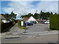
Pennington, club
Pennington Sports & Social Club, on Lodge Road.
Image: © Mike Faherty
Taken: 4 Sep 2011
0.17 miles
8
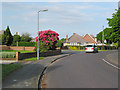
Junction of Priestlands Road and Whitaker Crescent, Lymington
Ok, so I took it just because of the rhododendron!
Image: © Peter Facey
Taken: 25 May 2006
0.20 miles
9
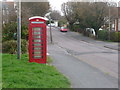
Lymington: phone box in Highfield Road
A red phone box on this suburban street.
Image: © Chris Downer
Taken: 20 Mar 2014
0.22 miles
10
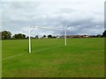
Pennington Recreation Ground
Football and cricket facilities, between Lodge Road and Yaldhurst Lane.
Image: © Mike Faherty
Taken: 4 Sep 2011
0.23 miles