IMAGES TAKEN NEAR TO
Marley Mount, LYMINGTON, SO41 6EP
Introduction
This page details the photographs taken nearby to Marley Mount, SO41 6EP by members of the Geograph project.
The Geograph project started in 2005 with the aim of publishing, organising and preserving representative images for every square kilometre of Great Britain, Ireland and the Isle of Man.

There are currently over 7.5m images from over14,400 individuals and you can help contribute to the project by visiting https://www.geograph.org.uk
Image Map
Images are licensed for reuse under creativecommons.org/licenses/by-sa/2.0
Notes
- Clicking on the map will re-center to the selected point.
- The higher the marker number, the further away the image location is from the centre of the postcode.
Image Listing (17 Images Found)
Images are licensed for reuse under creativecommons.org/licenses/by-sa/2.0
Image
Details
Distance
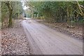
1
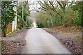
Marley Mount
The name of this lane is Marley Mount, in the area of Mead End.
Image: © mike smith
Taken: 24 Feb 2012
0.09 miles
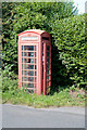
3
Tiptoe, phone box
On Middle Road, near the junction with Marley Mount; a notice inside the box states that it is "available for adoption" for £1.00, without its phone, for heritage value, if the Parish Council or another organisation wants to keep it.
Image: © Mike Faherty
Taken: 26 Sep 2009
0.15 miles
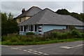
4
Boundway Farm, Mead End
This house, with "Boundway Farm" on the gate, is on a lane called Boundway, at Mead End.
Image: © mike smith
Taken: 24 Feb 2012
0.15 miles
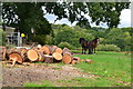
5
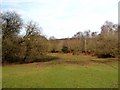
Forest lawn at Boundway Hill
On the southern edge of the New Forest.
Image: © Oliver Dixon
Taken: 24 Feb 2011
0.15 miles
6
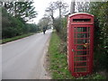
Telephone box in Middle Road
It was impossible to open the door to this box owing to the pile of tarmac that had been dumped to its right. The phone was off the hook and hanging by its cord. Curiously, it was not one of those with a notice inside threatening abandonment by BT.
Image: © Peter Facey
Taken: 23 Aug 2009
0.16 miles
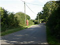
7
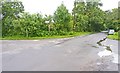
Cross Roads
These are only minor roads, connecting local farms and houses near the southern boundary of the New Forest.
Image: © mike smith
Taken: 4 Jul 2012
0.16 miles
8
Tiptoe: telephone box
A woman travels ahorseback past this telephone box which has seen better days, as has the Yellow Pages directory inside.
Image: © Chris Downer
Taken: 1 Mar 2009
0.17 miles
9
Dirt Road near Mead End
This unmade road provides access to a number of prestigious properties.
Image: © mike smith
Taken: 24 Feb 2012
0.17 miles
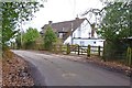
10
Houses by crossroads, Middle Road, Tiptoe
Image: © David Martin
Taken: 20 Aug 2018
0.17 miles