IMAGES TAKEN NEAR TO
Jordans Lane, LYMINGTON, SO41 6AR
Introduction
This page details the photographs taken nearby to Jordans Lane, SO41 6AR by members of the Geograph project.
The Geograph project started in 2005 with the aim of publishing, organising and preserving representative images for every square kilometre of Great Britain, Ireland and the Isle of Man.

There are currently over 7.5m images from over14,400 individuals and you can help contribute to the project by visiting https://www.geograph.org.uk
Image Map
Images are licensed for reuse under creativecommons.org/licenses/by-sa/2.0
Notes
- Clicking on the map will re-center to the selected point.
- The higher the marker number, the further away the image location is from the centre of the postcode.
Image Listing (23 Images Found)
Images are licensed for reuse under creativecommons.org/licenses/by-sa/2.0
Image
Details
Distance
1
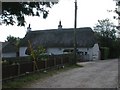
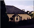
Sway, thatched cottage
"White Cottage" in Jordans Lane.
Image: © Mike Faherty
Taken: 25 Sep 2009
0.06 miles
3
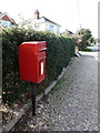
Sway: postbox № SO41 53, Manchester Road
A standard Elizabeth II-reign postbox mounted on a metal pole, serving the eastern part of the village.
Image: © Chris Downer
Taken: 25 Mar 2012
0.09 miles
4
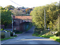
Sway, railway bridge
Bridge carrying the Southampton to Bournemouth line over Manchester Road.
Image: © Mike Faherty
Taken: 25 Sep 2009
0.09 miles
5
Railway bridge, Manchester Road, Sway
The main line to Bournemouth crosses.
Image: © Robin Webster
Taken: 30 Oct 2017
0.10 miles
6
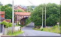
Manchester Road, Sway
At this point the railway goes over the road on a traditional brick arch bridge.
Half a kilometre in either direction, the railway passes under the roads.
Image: © mike smith
Taken: 23 Jun 2012
0.10 miles
7
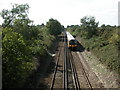
Durnstown, railway
As seen from a footbridge at the southern tip of the heathland; a train has just left Sway station, Southampton-bound.
Image: © Mike Faherty
Taken: 25 Sep 2009
0.12 miles
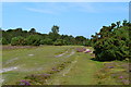
8

New Forest to the north east of Sway
This is where the New Forest begins at the boundary of Sway village.
Image: © mike smith
Taken: 23 Jun 2012
0.17 miles
9
Former Sway Bible Christian Chapel
Erected in 1864. Closed in 1900 and then converted into a private residence.
Image: © Michael FORD
Taken: Unknown
0.19 miles
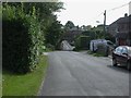
10

St James Road, Sway
Although it is named as a road, as can be seen, it is really a narrow lane.
Image: © mike smith
Taken: 23 Jun 2012
0.19 miles