IMAGES TAKEN NEAR TO
Monument Lane, LYMINGTON, SO41 5SE
Introduction
This page details the photographs taken nearby to Monument Lane, SO41 5SE by members of the Geograph project.
The Geograph project started in 2005 with the aim of publishing, organising and preserving representative images for every square kilometre of Great Britain, Ireland and the Isle of Man.

There are currently over 7.5m images from over14,400 individuals and you can help contribute to the project by visiting https://www.geograph.org.uk
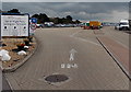
Image Map
Images are licensed for reuse under creativecommons.org/licenses/by-sa/2.0
Notes
- Clicking on the map will re-center to the selected point.
- The higher the marker number, the further away the image location is from the centre of the postcode.
Image Listing (162 Images Found)
Images are licensed for reuse under creativecommons.org/licenses/by-sa/2.0
Image
Details
Distance
1
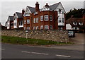
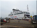
Ferry Point, Lymington
Row of houses on the north side of Undershore Road, opposite the entrance
to Lymington Pier railway station and the Isle of Wight Ferry terminal.
Image: © Jaggery
Taken: 27 Sep 2014
0.06 miles
2
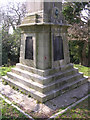
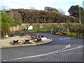
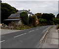
Base of the Walhampton Monument, east of Lymington
The Burrard Neale Monument or Walhampton Monument comprises a massive stone stepped plinth, surmounted by 75 foot high tapered obelisk. Each of the four faces of the base has a large iron plaque giving a fairly lengthy account of Sir Harry Burrard Neale's life in wildly varying type sizes. It was erected in 1840, to the memory of Sir Harry Burrard Neale BT. G.C.B., G.C.M.G., M.P. for Lymington in 1832. Many have seen the top of this obelisk sticking out of the trees on the east side of the Lymington river, the base is found near a right-angle in Monument Lane. In this picture you can see the results of copper leaching out of the bronze armorial above the iron plaque on eastern face.
Image: © Jim Champion
Taken: 1 Apr 2005
0.07 miles
3
Isle of Wight Ferry terminal entrance, Lymington
From Undershore Road. The ferry goes to Yarmouth on the Isle of Wight.
Image: © Jaggery
Taken: 27 Sep 2014
0.07 miles
4
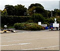
Old anchor in a Lymington car park
I saw several similar old anchors in Lymington today. This one is at the Undershore Road edge of Lymington Pier railway station and ferry terminal car park.
Image: © Jaggery
Taken: 27 Sep 2014
0.08 miles
5
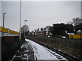
View north from Lymington Pier station
Looking north from near the north end of Lymington Pier railway station. The waiting area for vehicles boarding the ferry to Yarmouth (Isle of Wight) is behind the fence on the right.
Image: © Richard Vince
Taken: 19 Jan 2013
0.08 miles
6
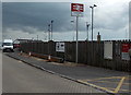
Anchor, Lymington
Anchor at the exit of the Whitelink Ferry terminal car park.
Image: © Maigheach-gheal
Taken: 26 Dec 2009
0.08 miles
7
Lymington Pier railway station name sign
The station entrance is from Undershore Road. The Isle of Wight Ferry terminal is nearby.
Image: © Jaggery
Taken: 27 Sep 2014
0.08 miles
8
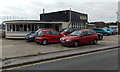
Pier Garage, Lymington
Located in Undershore Road, near Lymington Pier railway station and the Isle of Wight Ferry terminal.
Image: © Jaggery
Taken: 27 Sep 2014
0.09 miles
9
Undershore Road, Lymington
On the north side of Lymington Pier railway station and the Isle of Wight Ferry terminal.
Image: © Jaggery
Taken: 27 Sep 2014
0.09 miles