IMAGES TAKEN NEAR TO
Hundred Lane, LYMINGTON, SO41 5RG
Introduction
This page details the photographs taken nearby to Hundred Lane, SO41 5RG by members of the Geograph project.
The Geograph project started in 2005 with the aim of publishing, organising and preserving representative images for every square kilometre of Great Britain, Ireland and the Isle of Man.

There are currently over 7.5m images from over14,400 individuals and you can help contribute to the project by visiting https://www.geograph.org.uk
Image Map
Images are licensed for reuse under creativecommons.org/licenses/by-sa/2.0
Notes
- Clicking on the map will re-center to the selected point.
- The higher the marker number, the further away the image location is from the centre of the postcode.
Image Listing (11 Images Found)
Images are licensed for reuse under creativecommons.org/licenses/by-sa/2.0
Image
Details
Distance
1
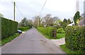
Hundred Lane, Portmore
This part of the lane is residential with homes either side for about a third of a kilometre.
Image: © mike smith
Taken: 3 Apr 2014
0.01 miles
2
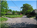
Hundred Lane, Portmore
Hundred Lane emerges onto the B3054 at the vanishing point of the road in this picture.
Image: © Peter Facey
Taken: 25 May 2006
0.03 miles
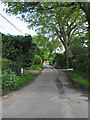
3
Hundred Lane, Portmore
This is the lane near to its junction with the B3054.
Image: © mike smith
Taken: 3 Apr 2014
0.06 miles
4
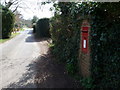
Portmore: postbox № SO41 15
The hamlet of Portmore is served postally by this Elizabeth II-reign lamp box set into a brick pillar. The box is emptied on weekdays at 5pm and on Saturdays at 7:30am.
Image: © Chris Downer
Taken: 25 Mar 2012
0.07 miles
5
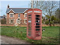
Portmore: the telephone box
This red telephone box stands on the little green, and a poster on the door shouts SAVE ME, pointing passersby to the 'redphoneboxesinnewforest' website - www.redphoneboxesinnewforest.co.uk
Image: © Chris Downer
Taken: 25 Mar 2012
0.08 miles
6
Green in Portmore
This green is at the junction of Warborne Lane and Jordans Lane.
Image: © mike smith
Taken: 3 Apr 2014
0.08 miles
7
Downtown Portmore
A small community on the southern edge of the New Forest.
Image: © Jonathan Billinger
Taken: 7 Nov 2013
0.08 miles
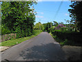
8
Warborne Lane, Portmore
Warborne Lane passes through Portmore and emerges onto the B3054 where the red car is.
Image: © Peter Facey
Taken: 25 May 2006
0.09 miles
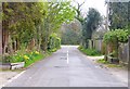
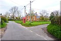
9
Portmore hamlet, nr Lymington
Portmore is a confluence of four single-track lanes around which there is dispersed secluded housing. This picture shows the centre of Portmore from the lane from Warborne. There is a telephone box, a seat and a noticeboard - and that's it.
Image: © Peter Facey
Taken: 25 May 2006
0.10 miles
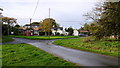
10
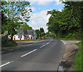
B3054 road junction at Portmore
The hamlet of Portmore is on the left. There are two roads to it on the left, one in front of the white bungalow and one behind it.
Image: © Peter Facey
Taken: 25 May 2006
0.11 miles