IMAGES TAKEN NEAR TO
Belmore Lane, LYMINGTON, SO41 3NN
Introduction
This page details the photographs taken nearby to Belmore Lane, SO41 3NN by members of the Geograph project.
The Geograph project started in 2005 with the aim of publishing, organising and preserving representative images for every square kilometre of Great Britain, Ireland and the Isle of Man.

There are currently over 7.5m images from over14,400 individuals and you can help contribute to the project by visiting https://www.geograph.org.uk
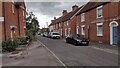
Image Map
Images are licensed for reuse under creativecommons.org/licenses/by-sa/2.0
Notes
- Clicking on the map will re-center to the selected point.
- The higher the marker number, the further away the image location is from the centre of the postcode.
Image Listing (107 Images Found)
Images are licensed for reuse under creativecommons.org/licenses/by-sa/2.0
Image
Details
Distance
1
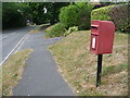
Lymington: postbox № SO41 82, Belmore Lane
This postbox stands alongside a small portion of the pavement in Belmore Lane which is raised slightly from the main carriageway, and separated by a small grass bank. It is emptied finally at 5:30pm on weekdays and at 11:45am on Saturdays.
Image: © Chris Downer
Taken: 11 Jun 2011
0.09 miles
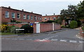
2
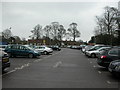
Lymington, car park
Off Powlett Road, operated by New Forest District Council.
Image: © Mike Faherty
Taken: 5 Feb 2011
0.12 miles
3
Daniell's Walk, Lymington
Daniell's Walk is a minor residential road in Lymington, in Hampshire.
Image: © Malc McDonald
Taken: 18 Aug 2021
0.13 miles
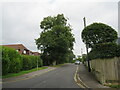
4
Lymington, street lamps
Two of several on Church Lane; cast-iron, distinctive, presumably originally lit by gas.
Image: © Mike Faherty
Taken: 5 Feb 2011
0.15 miles
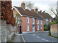
5
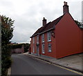
Belmore Lane
Belmore Lane Terrace Cottages
Image: © Shaun Ferguson
Taken: 30 Jul 2021
0.16 miles
6
Wykeham Place, Lymington
Residential cul-de-sac viewed from Rowlett Road.
Image: © Jaggery
Taken: 27 Sep 2014
0.16 miles
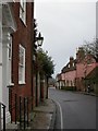
7
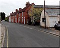
Belmore Lane, Lymington
Viewed from the corner of St Thomas Street looking past Hoare Banks stonemasons on the right.
Image: © Jaggery
Taken: 27 Sep 2014
0.16 miles
8
36 Church Lane, Lymington
Elm Grove House is a grade II listed building from the early to mid 18th century.
Image: © Robin Webster
Taken: 9 Dec 2015
0.17 miles
9
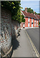
Church Lane
On the left is the serpentine garden wall shown in Image], leading towards some Georgian cottages.
Image: © Anne Burgess
Taken: 2 Jul 2014
0.17 miles
10
Elm Grove House, Lymington
18th century house in Church Lane, Grade II listed in 1974.
Image: © Jaggery
Taken: 27 Sep 2014
0.17 miles