IMAGES TAKEN NEAR TO
Mulberry Grove, LYMINGTON, SO41 0ZN
Introduction
This page details the photographs taken nearby to Mulberry Grove, SO41 0ZN by members of the Geograph project.
The Geograph project started in 2005 with the aim of publishing, organising and preserving representative images for every square kilometre of Great Britain, Ireland and the Isle of Man.

There are currently over 7.5m images from over14,400 individuals and you can help contribute to the project by visiting https://www.geograph.org.uk
Image Map
Images are licensed for reuse under creativecommons.org/licenses/by-sa/2.0
Notes
- Clicking on the map will re-center to the selected point.
- The higher the marker number, the further away the image location is from the centre of the postcode.
Image Listing (39 Images Found)
Images are licensed for reuse under creativecommons.org/licenses/by-sa/2.0
Image
Details
Distance
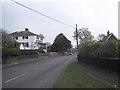
2
Christchurch Road (A337)
Looking from Lymington Road (the B3058) at Christchurch Road (the A337).
Image: © Oscar Taylor
Taken: 24 Jun 2023
0.08 miles
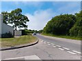
5

Everton : Christchurch Road A377
A road heading through the village of Everton.
Image: © Lewis Clarke
Taken: 26 Mar 2018
0.09 miles
6
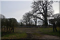
Everton : Grassy Field & Gate
A grassy field seen off of Christchurch Road.
Image: © Lewis Clarke
Taken: 26 Mar 2018
0.09 miles
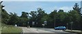
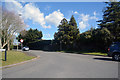
7
Junction of A337 and Everton Road, edge of Everton, Hants
Image: © mike smith
Taken: 7 Mar 2007
0.10 miles
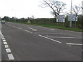
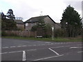
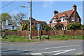
8
Everton : Everton Road
Looking up Everton Road from Christchurch Road.
Image: © Lewis Clarke
Taken: 26 Mar 2018
0.10 miles
9
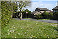
Roadside daisies and dandelions at the end of Everton Road
Image: © David Martin
Taken: 8 Apr 2019
0.11 miles
10
Houses on the corner of Wainsford Road
Image: © David Martin
Taken: 8 Apr 2019
0.11 miles