IMAGES TAKEN NEAR TO
Everton Road, LYMINGTON, SO41 0ZA
Introduction
This page details the photographs taken nearby to Everton Road, SO41 0ZA by members of the Geograph project.
The Geograph project started in 2005 with the aim of publishing, organising and preserving representative images for every square kilometre of Great Britain, Ireland and the Isle of Man.

There are currently over 7.5m images from over14,400 individuals and you can help contribute to the project by visiting https://www.geograph.org.uk
Image Map
Images are licensed for reuse under creativecommons.org/licenses/by-sa/2.0
Notes
- Clicking on the map will re-center to the selected point.
- The higher the marker number, the further away the image location is from the centre of the postcode.
Image Listing (33 Images Found)
Images are licensed for reuse under creativecommons.org/licenses/by-sa/2.0
Image
Details
Distance
1
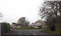
Everton Road at Old Christchurch Road entrance
Image: © John Firth
Taken: 16 Apr 2013
0.04 miles
2
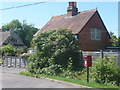
Everton: postbox № SO41 79, Farmers Walk
The westernmost of Everton's three postboxes stands in Farmers Walk, which is a segment of the old main road, a quiet cul-de-sac now that the village is bypassed. The box is emptied finally at 5pm on weekdays and at 9am on Saturdays.
Image: © Chris Downer
Taken: 26 Jun 2011
0.07 miles
3
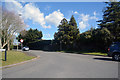
Everton : Everton Road
Looking up Everton Road from Christchurch Road.
Image: © Lewis Clarke
Taken: 26 Mar 2018
0.08 miles
4
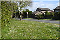
Roadside daisies and dandelions at the end of Everton Road
Image: © David Martin
Taken: 8 Apr 2019
0.09 miles
5
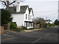
"The White House"
This is on Old Christchurch Road, just west of the centre of Everton Village.
Image: © mike smith
Taken: 12 Mar 2007
0.09 miles
7
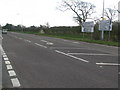
Junction of A337 and Everton Road, edge of Everton, Hants
Image: © mike smith
Taken: 7 Mar 2007
0.11 miles
8
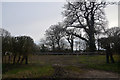
Everton : Grassy Field & Gate
A grassy field seen off of Christchurch Road.
Image: © Lewis Clarke
Taken: 26 Mar 2018
0.12 miles
9
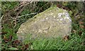
Old Milestone, Former A337, Farmers Walk, Everton
The milestone is located by 'Alwyne' on the old Christchurch road, on the narrow verge under the hedge, on the north side of the road. Parish of Milford on Sea (New Forest District). Carved stone post, Lymington stone design, erected by the Lymington, Lyndhurst & Rumbridge turnpike trust in the 19th century.
Inscription once read:-
(Lymington)
(3)
(Christchurch)
(9)
Milestone Society National ID: HA_LYCC03
Image: © Mike Faherty
Taken: Unknown
0.12 miles
10
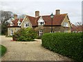
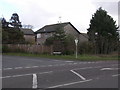
Hart's Farmhouse
The farm is long-gone - now covered with housing, but the old farmhouse still stands proud.
Image: © mike smith
Taken: 12 Mar 2007
0.14 miles