IMAGES TAKEN NEAR TO
Overstrand Crescent, LYMINGTON, SO41 0SZ
Introduction
This page details the photographs taken nearby to Overstrand Crescent, SO41 0SZ by members of the Geograph project.
The Geograph project started in 2005 with the aim of publishing, organising and preserving representative images for every square kilometre of Great Britain, Ireland and the Isle of Man.

There are currently over 7.5m images from over14,400 individuals and you can help contribute to the project by visiting https://www.geograph.org.uk
Image Map
Images are licensed for reuse under creativecommons.org/licenses/by-sa/2.0
Notes
- Clicking on the map will re-center to the selected point.
- The higher the marker number, the further away the image location is from the centre of the postcode.
Image Listing (135 Images Found)
Images are licensed for reuse under creativecommons.org/licenses/by-sa/2.0
Image
Details
Distance
1
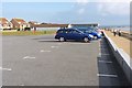
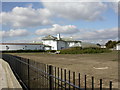
Hurst Road West Car Park
This is one of five car parks along this stretch of the coastline.
They are operated by New Forest District Council.
Image: © mike smith
Taken: 13 Oct 2011
0.08 miles
2
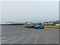
Hurst Road car park, Milford on Sea
The car park near the bowls club on Hurst Road.
Image: © Oscar Taylor
Taken: 24 Jun 2023
0.08 miles
3
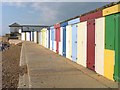
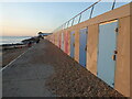
Beach Huts
This terrace of colourful beach huts is made from concrete blocks, rather than the more traditional timber.
Image: © mike smith
Taken: 13 Oct 2011
0.09 miles
4
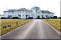
The White House
This building was constructed in 1903 by the Munro family who were the original owners of Rhinefield House in the New Forest. The house remained in the family until 1938 when it was sold to Middlesex County Council, and it became a children's hospital, mainly for child TB sufferers, until 1983. After remaining empty and somewhat derelict, it was purchased by a builder in 1997 and converted into 14 luxury apartments.
Image: © mike smith
Taken: 13 Oct 2011
0.09 miles
5
Milford on Sea, White House
On Hurst Road, overlooking the sea; large house with curving wings, built 1902 as summer home; later, evacuation centre, school, now flats. http://www.milfordonsea.com/the_white_house.htm Listed by English Heritage: http://www.imagesofengland.org.uk/Details/Default.aspx?id=415557&mode=adv
Image: © Mike Faherty
Taken: 9 Mar 2010
0.09 miles
6
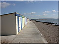
Milford on Sea, beach chalets
On the promenade; looking towards Keyhaven.
Image: © Mike Faherty
Taken: 9 Mar 2010
0.09 miles
7
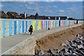
Modern beach huts, Milford on Sea
With the upper promenade forming the roof.
Image: © David Martin
Taken: 24 Sep 2018
0.09 miles
8
Beach huts on the promenade at Milford on Sea
Built into the modern sea wall.
Image: © Rod Allday
Taken: 21 Jan 2023
0.09 miles
9
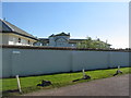
The White House, landward side
Seen from beyond the boundary wall.
Image: © E Gammie
Taken: 6 Sep 2015
0.09 miles
10
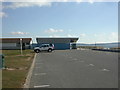
Milford on Sea, public conveniences
At the eastern end of Hurst Road West Car Park, overlooking the sea.
Image: © Mike Faherty
Taken: 9 Mar 2010
0.09 miles